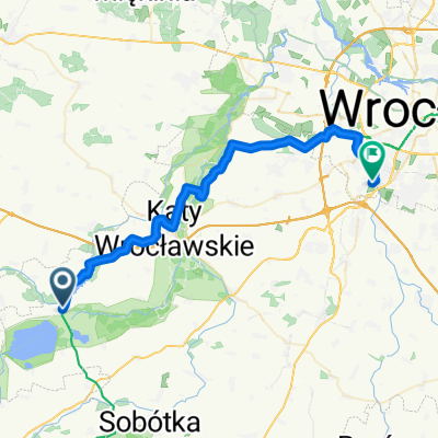
Sob贸tka 2
A cycling route starting in K膮ty Wroc艂awskie, Lower Silesian Voivodeship, Poland.
Overview
About this route
- -:--
- Duration
- 104.7 km
- Distance
- 569 m
- Ascent
- 566 m
- Descent
- ---
- Avg. speed
- 245 m
- Avg. speed
Route quality
Waytypes & surfaces along the route
Waytypes
Road
77 km
(74 %)
Busy road
10.7 km
(10 %)
Surfaces
Paved
62.3 km
(60 %)
Unpaved
0.9 km
(<1 %)
Asphalt
62.3 km
(60 %)
Loose gravel
0.6 km
(<1 %)
Route highlights
Points of interest along the route
Point of interest after 4.6 km
Mauzoleum
Point of interest after 5.6 km
Pa艂ac Krobielowice
Point of interest after 35.4 km
Zamek G贸rka
Point of interest after 37.1 km
Kamienio艂om
Point of interest after 58.2 km
Ruiny Zamku w Pankowie
Point of interest after 68.4 km
Zamek
Point of interest after 79.2 km
Pa艂ac Siedlimowice
Point of interest after 82.9 km
Pa艂ac Domanice
Point of interest after 89.4 km
Pa艂ac Mani贸w
Point of interest after 93.1 km
Ruina
Continue with Bikemap
Use, edit, or download this cycling route
You would like to ride Sob贸tka 2 or customize it for your own trip? Here is what you can do with this Bikemap route:
Free features
- Save this route as favorite or in collections
- Copy & plan your own version of this route
- Sync your route with Garmin or Wahoo
Premium features
Free trial for 3 days, or one-time payment. More about Bikemap Premium.
- Navigate this route on iOS & Android
- Export a GPX / KML file of this route
- Create your custom printout (try it for free)
- Download this route for offline navigation
Discover more Premium features.
Get Bikemap PremiumFrom our community
Other popular routes starting in K膮ty Wroc艂awskie
- Wyjazd dla prawdziwych m臋偶czyzn - dzie艅 1
- Distance
- 62.3 km
- Ascent
- 881 m
- Descent
- 436 m
- Location
- K膮ty Wroc艂awskie, Lower Silesian Voivodeship, Poland
- K膮ty - 艢widnica - K膮ty - 艢widnica
- Distance
- 53.9 km
- Ascent
- 633 m
- Descent
- 525 m
- Location
- K膮ty Wroc艂awskie, Lower Silesian Voivodeship, Poland
- Gruszkowy Ciechan - na piero偶ki do Sob贸tki
- Distance
- 41 km
- Ascent
- 314 m
- Descent
- 314 m
- Location
- K膮ty Wroc艂awskie, Lower Silesian Voivodeship, Poland
- K膮ty - P艂onica R9
- Distance
- 95.8 km
- Ascent
- 609 m
- Descent
- 498 m
- Location
- K膮ty Wroc艂awskie, Lower Silesian Voivodeship, Poland
- K膮ty Wroc艂awskie P臋tla Bielika
- Distance
- 22.9 km
- Ascent
- 123 m
- Descent
- 124 m
- Location
- K膮ty Wroc艂awskie, Lower Silesian Voivodeship, Poland
- Recovered Route
- Distance
- 4.8 km
- Ascent
- 34 m
- Descent
- 33 m
- Location
- K膮ty Wroc艂awskie, Lower Silesian Voivodeship, Poland
- CX K膮ty - Las Raty艅ski - K膮ty
- Distance
- 61.6 km
- Ascent
- 102 m
- Descent
- 108 m
- Location
- K膮ty Wroc艂awskie, Lower Silesian Voivodeship, Poland
- Dolina Bystrzycy
- Distance
- 47.3 km
- Ascent
- 184 m
- Descent
- 186 m
- Location
- K膮ty Wroc艂awskie, Lower Silesian Voivodeship, Poland
Open it in the app