

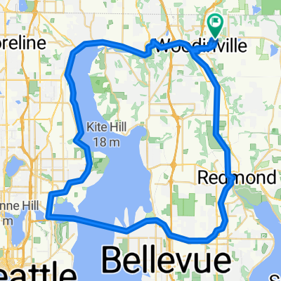
NE 171st St, Woodinville to 17255 135th Ave NE, Woodinville
A cycling route starting in Woodinville, Washington, United States.
Overview
About this route
- 2 h 3 min
- Duration
- 35.2 km
- Distance
- 297 m
- Ascent
- 292 m
- Descent
- 17.1 km/h
- Avg. speed
- 22 m
- Max. altitude
Route quality
Waytypes & surfaces along the route
Waytypes
Cycleway
29.6 km
(84 %)
Pedestrian area
2.1 km
(6 %)
Surfaces
Paved
33.4 km
(95 %)
Asphalt
31.7 km
(90 %)
Concrete
1.8 km
(5 %)
Undefined
1.8 km
(5 %)
Continue with Bikemap
Use, edit, or download this cycling route
You would like to ride NE 171st St, Woodinville to 17255 135th Ave NE, Woodinville or customize it for your own trip? Here is what you can do with this Bikemap route:
Free features
- Save this route as favorite or in collections
- Copy & plan your own version of this route
- Sync your route with Garmin or Wahoo
Premium features
Free trial for 3 days, or one-time payment. More about Bikemap Premium.
- Navigate this route on iOS & Android
- Export a GPX / KML file of this route
- Create your custom printout (try it for free)
- Download this route for offline navigation
Discover more Premium features.
Get Bikemap PremiumFrom our community
Other popular routes starting in Woodinville
 Half Lake Wa.-520 Bridge-Redmond-Woodinville
- Distance
- 59.2 km
- Ascent
- 338 m
- Descent
- 339 m
- Location
- Woodinville, Washington, United States
 Redmond-Woodenville Sammamish Trail
- Distance
- 11.6 km
- Ascent
- 17 m
- Descent
- 12 m
- Location
- Woodinville, Washington, United States
 22M - Woodinville 520 loop
- Distance
- 35.9 km
- Ascent
- 402 m
- Descent
- 399 m
- Location
- Woodinville, Washington, United States
 Sammamish River Trail, Woodinville to 2501 N Northlake Way, Seattle
- Distance
- 26.7 km
- Ascent
- 84 m
- Descent
- 84 m
- Location
- Woodinville, Washington, United States
 131st Ave NE, Woodinville to Sammamish River Trail, Bothell
- Distance
- 4.4 km
- Ascent
- 28 m
- Descent
- 75 m
- Location
- Woodinville, Washington, United States
 Day After Christmas Ride
- Distance
- 82.6 km
- Ascent
- 1,538 m
- Descent
- 1,535 m
- Location
- Woodinville, Washington, United States
 to/from school
- Distance
- 29.6 km
- Ascent
- 68 m
- Descent
- 153 m
- Location
- Woodinville, Washington, United States
 Woodinville to Marrymoor Park
- Distance
- 12.7 km
- Ascent
- 16 m
- Descent
- 16 m
- Location
- Woodinville, Washington, United States
Open it in the app