

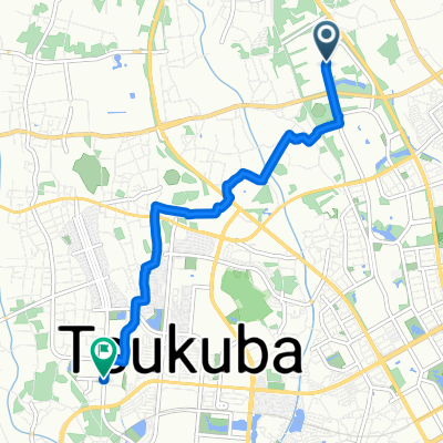
県道214号, Tsukuba to 92-17, Nishihoshubana, Kasukabe
A cycling route starting in Tsukuba, Ibaraki, Japan.
Overview
About this route
- 1 h 40 min
- Duration
- 35.9 km
- Distance
- 176 m
- Ascent
- 190 m
- Descent
- 21.6 km/h
- Avg. speed
- 43 m
- Max. altitude

Continue with Bikemap
Use, edit, or download this cycling route
You would like to ride 県道214号, Tsukuba to 92-17, Nishihoshubana, Kasukabe or customize it for your own trip? Here is what you can do with this Bikemap route:
Free features
- Save this route as favorite or in collections
- Copy & plan your own version of this route
- Sync your route with Garmin or Wahoo
Premium features
Free trial for 3 days, or one-time payment. More about Bikemap Premium.
- Navigate this route on iOS & Android
- Export a GPX / KML file of this route
- Create your custom printout (try it for free)
- Download this route for offline navigation
Discover more Premium features.
Get Bikemap PremiumFrom our community
Other popular routes starting in Tsukuba
 Tennodai 2-Chōme, Tsukuba to Tokodai 5-Chōme, Tsukuba
- Distance
- 6.6 km
- Ascent
- 21 m
- Descent
- 23 m
- Location
- Tsukuba, Ibaraki, Japan
 いしおかいこうか満喫コース
- Distance
- 44.7 km
- Ascent
- 359 m
- Descent
- 359 m
- Location
- Tsukuba, Ibaraki, Japan
 県道214号, Tsukuba to 92-17, Nishihoshubana, Kasukabe
- Distance
- 35.9 km
- Ascent
- 176 m
- Descent
- 190 m
- Location
- Tsukuba, Ibaraki, Japan
 tsukuba
- Distance
- 11.8 km
- Ascent
- 581 m
- Descent
- 79 m
- Location
- Tsukuba, Ibaraki, Japan
 Nakasugama, Tsukuba to 1-2, Tsukuba, Tsukuba
- Distance
- 10.8 km
- Ascent
- 553 m
- Descent
- 44 m
- Location
- Tsukuba, Ibaraki, Japan
 歴史ある「筑波」を堪能するコース
- Distance
- 16.3 km
- Ascent
- 48 m
- Descent
- 48 m
- Location
- Tsukuba, Ibaraki, Japan
 Tsukuba San
- Distance
- 12.1 km
- Ascent
- 61 m
- Descent
- 80 m
- Location
- Tsukuba, Ibaraki, Japan
 1-2, Tsukuba, Tsukuba to Higashihoshubana, Noda
- Distance
- 45.6 km
- Ascent
- 81 m
- Descent
- 612 m
- Location
- Tsukuba, Ibaraki, Japan
Open it in the app