

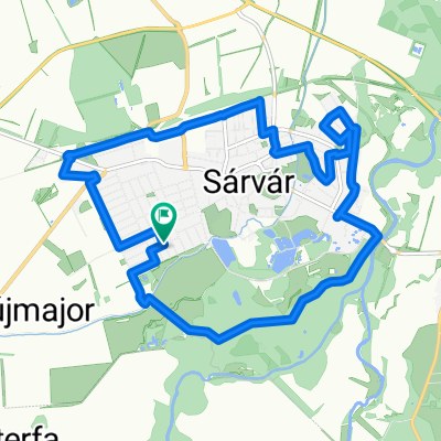
Gárdonyi Géza utca 27., Sarvar to Gárdonyi Géza utca, Sarvar
A cycling route starting in Sárvár, Vas County, Hungary.
Overview
About this route
- 1 h 7 min
- Duration
- 20.9 km
- Distance
- 101 m
- Ascent
- 126 m
- Descent
- 18.8 km/h
- Avg. speed
- 218 m
- Max. altitude
Route quality
Waytypes & surfaces along the route
Waytypes
Road
3.3 km
(16 %)
Quiet road
1.3 km
(6 %)
Surfaces
Paved
4 km
(19 %)
Unpaved
0.6 km
(3 %)
Asphalt
4 km
(19 %)
Ground
0.6 km
(3 %)
Undefined
16.3 km
(78 %)
Continue with Bikemap
Use, edit, or download this cycling route
You would like to ride Gárdonyi Géza utca 27., Sarvar to Gárdonyi Géza utca, Sarvar or customize it for your own trip? Here is what you can do with this Bikemap route:
Free features
- Save this route as favorite or in collections
- Copy & plan your own version of this route
- Sync your route with Garmin or Wahoo
Premium features
Free trial for 3 days, or one-time payment. More about Bikemap Premium.
- Navigate this route on iOS & Android
- Export a GPX / KML file of this route
- Create your custom printout (try it for free)
- Download this route for offline navigation
Discover more Premium features.
Get Bikemap PremiumFrom our community
Other popular routes starting in Sárvár
 Sárvár belvárosi körút 14 km
- Distance
- 14 km
- Ascent
- 24 m
- Descent
- 25 m
- Location
- Sárvár, Vas County, Hungary
 Farkaserdő II
- Distance
- 38.7 km
- Ascent
- 136 m
- Descent
- 133 m
- Location
- Sárvár, Vas County, Hungary
 Névtelen Út - Csallóköz utca 16a
- Distance
- 12.2 km
- Ascent
- 41 m
- Descent
- 84 m
- Location
- Sárvár, Vas County, Hungary
 VELOREGIO_02.
- Distance
- 181.1 km
- Ascent
- 227 m
- Descent
- 224 m
- Location
- Sárvár, Vas County, Hungary
 VELOREGIO_10.
- Distance
- 20 km
- Ascent
- 20 m
- Descent
- 22 m
- Location
- Sárvár, Vas County, Hungary
 1989 - In den Südosten Europas - 05. Tag - Sárvár - Balatonföldvár
- Distance
- 113.6 km
- Ascent
- 361 m
- Descent
- 408 m
- Location
- Sárvár, Vas County, Hungary
 VELOREGIO_17
- Distance
- 66.3 km
- Ascent
- 311 m
- Descent
- 468 m
- Location
- Sárvár, Vas County, Hungary
 Sárvár - Szajki tavak - Sárvár
- Distance
- 72.5 km
- Ascent
- 385 m
- Descent
- 385 m
- Location
- Sárvár, Vas County, Hungary
Open it in the app