

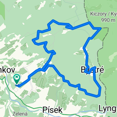
Szańce Jabłonkowskie
A cycling route starting in Jablunkov, Moravskoslezský kraj, Czechia.
Overview
About this route
Route from Jabłonków to the earthworks, forts, redoubts and other objects that are part of the so-called 'Jabłonków Earthworks' from the 16th to the 18th centuries.
- -:--
- Duration
- 58.5 km
- Distance
- 1,063 m
- Ascent
- 1,064 m
- Descent
- ---
- Avg. speed
- ---
- Max. altitude

Route highlights
Points of interest along the route

Point of interest after 0.1 km
Jabłonków rynek
Point of interest after 3.4 km
szaniec
Point of interest after 3.4 km
szaniec

Point of interest after 3.4 km
Szańce Dolna Lomna
Point of interest after 9 km
szaniec

Point of interest after 9.1 km
szaniec?

Point of interest after 10.4 km
Szańce Jabłonkowskie
Point of interest after 12 km
szaniec

Point of interest after 12.1 km
Stare Szańce (Alte Schanze)
Point of interest after 14.1 km
Szaniec
Point of interest after 14.7 km
Szaniec

Point of interest after 20.3 km
Szańce Barziny

Point of interest after 23.1 km
Szańce Hrczawa

Point of interest after 25.5 km
Mały Szaniec (Wały)
Point of interest after 25.9 km
Szaniec ?
Point of interest after 34 km
Szaniec Kikula

Point of interest after 37.5 km
Koczy Zamek
Point of interest after 39.3 km
Ochodzita (Woli Szaniec)
Point of interest after 48.8 km
Szaniec ?
Point of interest after 50.5 km
Szaniec ?

Point of interest after 50.8 km
Suszańskie Szańce

Point of interest after 51.2 km
Szańce "Na Kempie"
Point of interest after 51.7 km
Szaniec ?
Continue with Bikemap
Use, edit, or download this cycling route
You would like to ride Szańce Jabłonkowskie or customize it for your own trip? Here is what you can do with this Bikemap route:
Free features
- Save this route as favorite or in collections
- Copy & plan your own version of this route
- Sync your route with Garmin or Wahoo
Premium features
Free trial for 3 days, or one-time payment. More about Bikemap Premium.
- Navigate this route on iOS & Android
- Export a GPX / KML file of this route
- Create your custom printout (try it for free)
- Download this route for offline navigation
Discover more Premium features.
Get Bikemap PremiumFrom our community
Other popular routes starting in Jablunkov
 Zimowa Jaworzynka, Hrćava & Studenićny
- Distance
- 41.9 km
- Ascent
- 594 m
- Descent
- 596 m
- Location
- Jablunkov, Moravskoslezský kraj, Czechia
 Kamienna chata i dolina Łomnej
- Distance
- 45.6 km
- Ascent
- 789 m
- Descent
- 788 m
- Location
- Jablunkov, Moravskoslezský kraj, Czechia
 Hexenberg
- Distance
- 14.5 km
- Ascent
- 438 m
- Descent
- 440 m
- Location
- Jablunkov, Moravskoslezský kraj, Czechia
 MTB - Písek - Bahenec - Kiczora - Jaworzynka - Hrčava - Trojmezí - Bukovec - Písek
- Distance
- 34.7 km
- Ascent
- 946 m
- Descent
- 946 m
- Location
- Jablunkov, Moravskoslezský kraj, Czechia
 Minćol 1394
- Distance
- 165.1 km
- Ascent
- 1,986 m
- Descent
- 1,986 m
- Location
- Jablunkov, Moravskoslezský kraj, Czechia
 Zimowa Jaworzynka, Hrćava & Studenićny
- Distance
- 41.9 km
- Ascent
- 581 m
- Descent
- 581 m
- Location
- Jablunkov, Moravskoslezský kraj, Czechia
 Velky Polom 25.10.14
- Distance
- 40 km
- Ascent
- 815 m
- Descent
- 815 m
- Location
- Jablunkov, Moravskoslezský kraj, Czechia
 podvečer okolo Bahence
- Distance
- 19.6 km
- Ascent
- 614 m
- Descent
- 618 m
- Location
- Jablunkov, Moravskoslezský kraj, Czechia
Open it in the app