

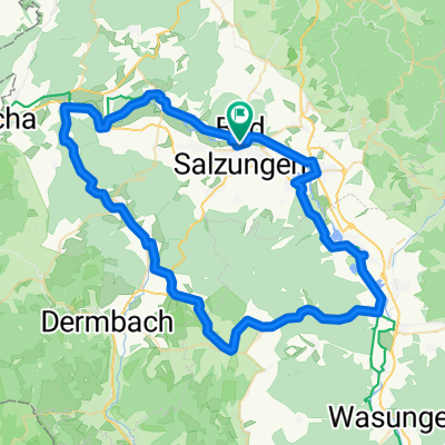
Salzungerrundweg
A cycling route starting in Bad Salzungen, Thuringia, Germany.
Overview
About this route
This is the Salzungerrundweg as it is signposted, so it's not 16 km as the signs say, but a bit more. It is partly well-paved and partly goes over the meadow. My personal favorite is the Werrabrücke bridge near Unterrohn.
- -:--
- Duration
- 22.6 km
- Distance
- 353 m
- Ascent
- 353 m
- Descent
- ---
- Avg. speed
- ---
- Max. altitude

Route quality
Waytypes & surfaces along the route
Waytypes
Track
9.5 km
(42 %)
Quiet road
6.3 km
(28 %)
Surfaces
Paved
9.5 km
(42 %)
Unpaved
9.7 km
(43 %)
Asphalt
8.6 km
(38 %)
Ground
5.4 km
(24 %)
Continue with Bikemap
Use, edit, or download this cycling route
You would like to ride Salzungerrundweg or customize it for your own trip? Here is what you can do with this Bikemap route:
Free features
- Save this route as favorite or in collections
- Copy & plan your own version of this route
- Sync your route with Garmin or Wahoo
Premium features
Free trial for 3 days, or one-time payment. More about Bikemap Premium.
- Navigate this route on iOS & Android
- Export a GPX / KML file of this route
- Create your custom printout (try it for free)
- Download this route for offline navigation
Discover more Premium features.
Get Bikemap PremiumFrom our community
Other popular routes starting in Bad Salzungen
 Werrastraße nach Werrastraße
- Distance
- 67.7 km
- Ascent
- 779 m
- Descent
- 832 m
- Location
- Bad Salzungen, Thuringia, Germany
 2001 Werratal Bad Salzungen bis Gerstungen
- Distance
- 48.9 km
- Ascent
- 326 m
- Descent
- 354 m
- Location
- Bad Salzungen, Thuringia, Germany
 Kissel/Arnsberg-Dreiherrenstein-Steinbach/Messerweg-Bad Salzungen
- Distance
- 27.9 km
- Ascent
- 656 m
- Descent
- 278 m
- Location
- Bad Salzungen, Thuringia, Germany
 13.07.24 Bad Salzungen-Hörschel
- Distance
- 79.9 km
- Ascent
- 289 m
- Descent
- 331 m
- Location
- Bad Salzungen, Thuringia, Germany
 Bad Salzungen Inselsberg und zurück
- Distance
- 56.9 km
- Ascent
- 937 m
- Descent
- 937 m
- Location
- Bad Salzungen, Thuringia, Germany
 Main - Alpen 17. Teil: Bad Salzungen - Wanfried
- Distance
- 74 km
- Ascent
- 357 m
- Descent
- 419 m
- Location
- Bad Salzungen, Thuringia, Germany
 Moorgrundrunde
- Distance
- 31.8 km
- Ascent
- 337 m
- Descent
- 337 m
- Location
- Bad Salzungen, Thuringia, Germany
 Salzungerrundweg
- Distance
- 22.6 km
- Ascent
- 353 m
- Descent
- 353 m
- Location
- Bad Salzungen, Thuringia, Germany
Open it in the app