

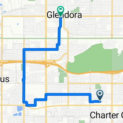
311 Nugget Ct, San Dimas to 311 Nugget Ct, San Dimas
A cycling route starting in Charter Oak, California, United States.
Overview
About this route
- 1 h 17 min
- Duration
- 20.5 km
- Distance
- 255 m
- Ascent
- 256 m
- Descent
- 16 km/h
- Avg. speed
- 255 m
- Max. altitude
Continue with Bikemap
Use, edit, or download this cycling route
You would like to ride 311 Nugget Ct, San Dimas to 311 Nugget Ct, San Dimas or customize it for your own trip? Here is what you can do with this Bikemap route:
Free features
- Save this route as favorite or in collections
- Copy & plan your own version of this route
- Sync your route with Garmin or Wahoo
Premium features
Free trial for 3 days, or one-time payment. More about Bikemap Premium.
- Navigate this route on iOS & Android
- Export a GPX / KML file of this route
- Create your custom printout (try it for free)
- Download this route for offline navigation
Discover more Premium features.
Get Bikemap PremiumFrom our community
Other popular routes starting in Charter Oak
 1626 E Ruddock St, Covina to 142 N Glendora Ave, Covina
- Distance
- 10.1 km
- Ascent
- 149 m
- Descent
- 158 m
- Location
- Charter Oak, California, United States
 1050 Avenida Loma Vista, San Dimas to 1805 Avenida Monte Vista, San Dimas
- Distance
- 5 km
- Ascent
- 98 m
- Descent
- 131 m
- Location
- Charter Oak, California, United States
 1009 Avenida Loma Vista, San Dimas to 1009 Avenida Loma Vista, San Dimas
- Distance
- 12.5 km
- Ascent
- 281 m
- Descent
- 283 m
- Location
- Charter Oak, California, United States
 Glendora Foothills Ride
- Distance
- 18.1 km
- Ascent
- 174 m
- Descent
- 199 m
- Location
- Charter Oak, California, United States
 Old Town Glendora
- Distance
- 8.2 km
- Ascent
- 47 m
- Descent
- 45 m
- Location
- Charter Oak, California, United States
 West Covina Boulevard 1130, San Dimas to West Covina Boulevard 1130, San Dimas
- Distance
- 9.8 km
- Ascent
- 64 m
- Descent
- 65 m
- Location
- Charter Oak, California, United States
 Relaxed route in La Verne
- Distance
- 8 km
- Ascent
- 94 m
- Descent
- 24 m
- Location
- Charter Oak, California, United States
 Electric/Santa Ana River Trail Loop
- Distance
- 183.6 km
- Ascent
- 379 m
- Descent
- 444 m
- Location
- Charter Oak, California, United States
Open it in the app