

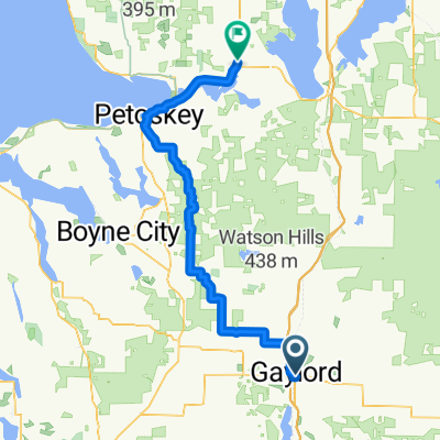
565 Crestwood Dr, Gaylord to 565 Crestwood Dr, Gaylord
A cycling route starting in Gaylord, Michigan, United States.
Overview
About this route
- 53 min
- Duration
- 14.1 km
- Distance
- 67 m
- Ascent
- 76 m
- Descent
- 16 km/h
- Avg. speed
- 420 m
- Max. altitude
Route quality
Waytypes & surfaces along the route
Waytypes
Quiet road
7.3 km
(52 %)
Cycleway
5.4 km
(38 %)
Surfaces
Paved
2.7 km
(19 %)
Asphalt
1.5 km
(11 %)
Paved (undefined)
1.1 km
(8 %)
Undefined
11.4 km
(81 %)
Continue with Bikemap
Use, edit, or download this cycling route
You would like to ride 565 Crestwood Dr, Gaylord to 565 Crestwood Dr, Gaylord or customize it for your own trip? Here is what you can do with this Bikemap route:
Free features
- Save this route as favorite or in collections
- Copy & plan your own version of this route
- Sync your route with Garmin or Wahoo
Premium features
Free trial for 3 days, or one-time payment. More about Bikemap Premium.
- Navigate this route on iOS & Android
- Export a GPX / KML file of this route
- Create your custom printout (try it for free)
- Download this route for offline navigation
Discover more Premium features.
Get Bikemap PremiumFrom our community
Other popular routes starting in Gaylord
 Lone Pine Road 2203, Gaylord to Lone Pine Road 2261, Gaylord
- Distance
- 0 km
- Ascent
- 0 m
- Descent
- 0 m
- Location
- Gaylord, Michigan, United States
 565 Crestwood Dr, Gaylord to 565 Crestwood Dr, Gaylord
- Distance
- 14.1 km
- Ascent
- 67 m
- Descent
- 76 m
- Location
- Gaylord, Michigan, United States
 DALMAC 2009 4 day east - Day 4 CLONED FROM ROUTE 308652
- Distance
- 107.7 km
- Ascent
- 178 m
- Descent
- 405 m
- Location
- Gaylord, Michigan, United States
 Gaylord - Indian River
- Distance
- 78.7 km
- Ascent
- 346 m
- Descent
- 567 m
- Location
- Gaylord, Michigan, United States
 Old State Rd, Gaylord to Old State Rd, Gaylord
- Distance
- 20.1 km
- Ascent
- 61 m
- Descent
- 67 m
- Location
- Gaylord, Michigan, United States
 Day 6-Mesick
- Distance
- 155.5 km
- Ascent
- 178 m
- Descent
- 306 m
- Location
- Gaylord, Michigan, United States
 East Main Street 114, Gaylord to Brookford Drive 2303, Toledo
- Distance
- 501.3 km
- Ascent
- 1,324 m
- Descent
- 1,544 m
- Location
- Gaylord, Michigan, United States
 Thirsty Sturgeon
- Distance
- 19.3 km
- Ascent
- 3 m
- Descent
- 105 m
- Location
- Gaylord, Michigan, United States
Open it in the app