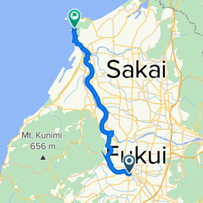
福井・坂井・永平寺観光地アクセスルート(東尋坊コース)
A cycling route starting in Fukui-shi, Fukui, Japan.
Overview
About this route
A course that runs from the center of Fukui along the Asuwa River, Hino River, and Kuzuryu River towards the sea to 'Tojinbo'.
- -:--
- Duration
- 27.3 km
- Distance
- 64 m
- Ascent
- 28 m
- Descent
- ---
- Avg. speed
- 44 m
- Max. altitude
Route quality
Waytypes & surfaces along the route
Waytypes
Quiet road
10.7 km
(39 %)
Track
5.7 km
(21 %)
Surfaces
Paved
3.8 km
(14 %)
Asphalt
2.7 km
(10 %)
Paved (undefined)
1.1 km
(4 %)
Undefined
23.5 km
(86 %)
Continue with Bikemap
Use, edit, or download this cycling route
You would like to ride 福井・坂井・永平寺観光地アクセスルート(東尋坊コース) or customize it for your own trip? Here is what you can do with this Bikemap route:
Free features
- Save this route as favorite or in collections
- Copy & plan your own version of this route
- Sync your route with Garmin or Wahoo
Premium features
Free trial for 3 days, or one-time payment. More about Bikemap Premium.
- Navigate this route on iOS & Android
- Export a GPX / KML file of this route
- Create your custom printout (try it for free)
- Download this route for offline navigation
Discover more Premium features.
Get Bikemap PremiumFrom our community
Other popular routes starting in Fukui-shi
- 2丁目 まで2番地
- Distance
- 80 km
- Ascent
- 943 m
- Descent
- 991 m
- Location
- Fukui-shi, Fukui, Japan
- 福井・坂井・永平寺観光地アクセスルート(一乗谷朝倉氏遺跡コース)
- Distance
- 12.5 km
- Ascent
- 56 m
- Descent
- 12 m
- Location
- Fukui-shi, Fukui, Japan
- 35−6−1, 福井市 to 35−6−1, 福井市
- Distance
- 95 km
- Ascent
- 2,074 m
- Descent
- 2,073 m
- Location
- Fukui-shi, Fukui, Japan
- チャレンジ!国見岳ヒルクライムコース
- Distance
- 72.2 km
- Ascent
- 3,123 m
- Descent
- 3,122 m
- Location
- Fukui-shi, Fukui, Japan
- 35−21, 福井市 to 32−10−1, 永平寺町
- Distance
- 53.4 km
- Ascent
- 1,133 m
- Descent
- 1,110 m
- Location
- Fukui-shi, Fukui, Japan
- 福井・坂井・永平寺観光地アクセスルート(東尋坊コース)
- Distance
- 27.3 km
- Ascent
- 64 m
- Descent
- 28 m
- Location
- Fukui-shi, Fukui, Japan
- Fukui - Echizen/Takefu
- Distance
- 20.5 km
- Ascent
- 34 m
- Descent
- 23 m
- Location
- Fukui-shi, Fukui, Japan
- 健康増進!!清水・日野川コース
- Distance
- 41.3 km
- Ascent
- 380 m
- Descent
- 377 m
- Location
- Fukui-shi, Fukui, Japan
Open it in the app