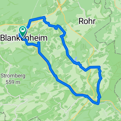
18 Ahrtalradroute
A cycling route starting in Blankenheim, North Rhine-Westphalia, Germany.
Overview
About this route
Super cycling tour.
Travel by train to Blankenheim Wald, then follow the main road to Blankenheim, continuing through forests and fields along the former train route, just follow the well-signposted Ahrtal route, unfortunately still over the federal road in Schuld (5 km) then continue through the vineyards to Mayschoß, Dernau, Ahrweiler, Bad Neuenahr, and Sinzig to the mouth of the Ahr. Head down the Rhine past the Peace Museum towards the docks, turning left into the city and continuing straight until the embankment, then right to Remagen train station.
- -:--
- Duration
- 85 km
- Distance
- 87 m
- Ascent
- 519 m
- Descent
- ---
- Avg. speed
- ---
- Max. altitude
Route highlights
Points of interest along the route
Photo after 6.5 km
Blankenheim
Photo after 55.6 km
Bei Mayschoß
Photo after 63.9 km
Photo after 80.4 km
Brücke an der Ahrmündung
Continue with Bikemap
Use, edit, or download this cycling route
You would like to ride 18 Ahrtalradroute or customize it for your own trip? Here is what you can do with this Bikemap route:
Free features
- Save this route as favorite or in collections
- Copy & plan your own version of this route
- Split it into stages to create a multi-day tour
- Sync your route with Garmin or Wahoo
Premium features
Free trial for 3 days, or one-time payment. More about Bikemap Premium.
- Navigate this route on iOS & Android
- Export a GPX / KML file of this route
- Create your custom printout (try it for free)
- Download this route for offline navigation
Discover more Premium features.
Get Bikemap PremiumFrom our community
Other popular routes starting in Blankenheim
- Ahrtour
- Distance
- 83.8 km
- Ascent
- 113 m
- Descent
- 557 m
- Location
- Blankenheim, North Rhine-Westphalia, Germany
- Erfttour 2016
- Distance
- 126.9 km
- Ascent
- 80 m
- Descent
- 538 m
- Location
- Blankenheim, North Rhine-Westphalia, Germany
- Blankenheim - Rundkurs
- Distance
- 32.8 km
- Ascent
- 576 m
- Descent
- 576 m
- Location
- Blankenheim, North Rhine-Westphalia, Germany
- Route der Vielseitigkeit
- Distance
- 57.1 km
- Ascent
- 125 m
- Descent
- 501 m
- Location
- Blankenheim, North Rhine-Westphalia, Germany
- Vulkaneifelrunde
- Distance
- 84.3 km
- Ascent
- 820 m
- Descent
- 820 m
- Location
- Blankenheim, North Rhine-Westphalia, Germany
- 18 Ahrtalradroute
- Distance
- 85 km
- Ascent
- 87 m
- Descent
- 519 m
- Location
- Blankenheim, North Rhine-Westphalia, Germany
- Ahr Radweg
- Distance
- 80.4 km
- Ascent
- 146 m
- Descent
- 576 m
- Location
- Blankenheim, North Rhine-Westphalia, Germany
- Ahrtalradweg
- Distance
- 95.5 km
- Ascent
- 142 m
- Descent
- 581 m
- Location
- Blankenheim, North Rhine-Westphalia, Germany
Open it in the app