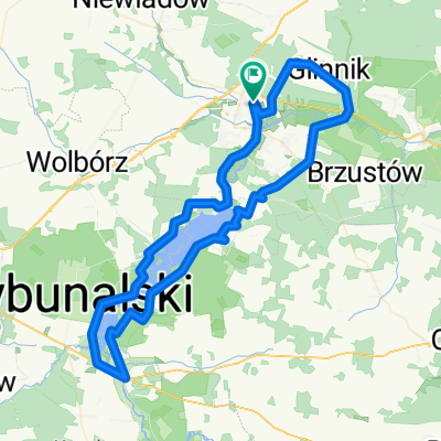
Po obu stronach Gaci
A cycling route starting in Tomasz贸w Mazowiecki, 艁贸d藕 Voivodeship, Poland.
Overview
About this route
- -:--
- Duration
- 100.2 km
- Distance
- 501 m
- Ascent
- 450 m
- Descent
- ---
- Avg. speed
- 222 m
- Avg. speed
Route quality
Waytypes & surfaces along the route
Waytypes
Quiet road
37.8 km
(38 %)
Road
31.7 km
(32 %)
Surfaces
Paved
50.4 km
(50 %)
Unpaved
8.6 km
(9 %)
Asphalt
40.7 km
(41 %)
Paving stones
7.9 km
(8 %)
Route highlights
Points of interest along the route
Photo after 5.9 km
Sknansen rzeki Pilicy
Point of interest after 15.6 km
Podziemna trasa turystyczna
Point of interest after 21.6 km
Klasztor
Point of interest after 25.9 km
呕ubry
Point of interest after 41.5 km
Zamek
Point of interest after 42.1 km
Bunkier
Point of interest after 42.1 km
ko艣ci贸艂 艢w. Idziego
Point of interest after 52 km
Bunkier w Konewce
Point of interest after 74.9 km
Ko艣ci贸艂 艣w. Wojciecha
Continue with Bikemap
Use, edit, or download this cycling route
You would like to ride Po obu stronach Gaci or customize it for your own trip? Here is what you can do with this Bikemap route:
Free features
- Save this route as favorite or in collections
- Copy & plan your own version of this route
- Sync your route with Garmin or Wahoo
Premium features
Free trial for 3 days, or one-time payment. More about Bikemap Premium.
- Navigate this route on iOS & Android
- Export a GPX / KML file of this route
- Create your custom printout (try it for free)
- Download this route for offline navigation
Discover more Premium features.
Get Bikemap PremiumFrom our community
Other popular routes starting in Tomasz贸w Mazowiecki
- Rajd woko艂o zalewu sulejowskiego +dojazd z TM
- Distance
- 66.3 km
- Ascent
- 182 m
- Descent
- 180 m
- Location
- Tomasz贸w Mazowiecki, 艁贸d藕 Voivodeship, Poland
- Smardzewice, Jele艅, Inow艂贸dz, Konewka
- Distance
- 51.2 km
- Ascent
- 1,315 m
- Descent
- 1,325 m
- Location
- Tomasz贸w Mazowiecki, 艁贸d藕 Voivodeship, Poland
- MTB/Cross Spa艂a, Jele艅, Smardzewice, Swolszewice, Wiaderno
- Distance
- 39.2 km
- Ascent
- 167 m
- Descent
- 167 m
- Location
- Tomasz贸w Mazowiecki, 艁贸d藕 Voivodeship, Poland
- Tomaszow Maz. - Lodz
- Distance
- 67.3 km
- Ascent
- 142 m
- Descent
- 113 m
- Location
- Tomasz贸w Mazowiecki, 艁贸d藕 Voivodeship, Poland
- Rolna 22, Tomasz贸w Mazowiecki do Rolna 18/22, Tomasz贸w Mazowiecki
- Distance
- 19.3 km
- Ascent
- 132 m
- Descent
- 134 m
- Location
- Tomasz贸w Mazowiecki, 艁贸d藕 Voivodeship, Poland
- TM-Inow艂贸dz-TM
- Distance
- 36.4 km
- Ascent
- 99 m
- Descent
- 98 m
- Location
- Tomasz贸w Mazowiecki, 艁贸d藕 Voivodeship, Poland
- Tomasz贸w-Zalew-Inow艂贸d藕-Spa艂a
- Distance
- 55.5 km
- Ascent
- 172 m
- Descent
- 175 m
- Location
- Tomasz贸w Mazowiecki, 艁贸d藕 Voivodeship, Poland
- around Zalew Sulejewski
- Distance
- 55.9 km
- Ascent
- 216 m
- Descent
- 213 m
- Location
- Tomasz贸w Mazowiecki, 艁贸d藕 Voivodeship, Poland
Open it in the app