

L05EmmersdorfKrems
A cycling route starting in Emmersdorf an der Donau, Lower Austria, Austria.
Overview
About this route
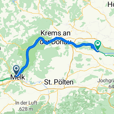
Through the enchanted garden to a romantic landscape / The tour takes you via the Danube Bike Path from the Danube town of Emmersdorf through the Wachau, a landscape shaped by human hand, and beyond to Krems, a statutory city on the Danube, i.e. it has the authority of both a city and a district. On your ride through the Wachau, a UNESCO World Heritage landscape, you pass through Aggsbach, Spitz and Weissenkirchen, among other towns, before arriving at your destination: Krems, a center of commerce and culture. / IMPORTANT NOTE: / From February 2020 until the end of 2021, the Danube Cycle Trail will be diverted in the Höhe Ringstraße area of Krems, due to necessary pipeline works. Please follow the diversion signposts in the Krems city area. / Due to construction works on the bridge between Mautern and Stein (the Mauterner Brücke), there will be restrictions for cyclists, starting immediately! We recommend allowing enough time to cross the Danube elsewhere. Emmersdorf an der Donau - na desnem bregu Melk (pritok Melk) – Aggsbach - Willendorf in der Wachau - Schwallenbach - Spitz – Wosendorf in der Donau - Weisenkirchen in der Wachau - Durnstein - Unterloiben - na desnem bregu Mautern an der Donau - Krems an der Donau PRENOČIŠČE (35 km, 82 m)
- -:--
- Duration
- 34.4 km
- Distance
- 190 m
- Ascent
- 200 m
- Descent
- ---
- Avg. speed
- 239 m
- Max. altitude

Route quality
Waytypes & surfaces along the route
Waytypes
Cycleway
13.1 km
(38 %)
Road
10 km
(29 %)
Surfaces
Paved
33.7 km
(98 %)
Asphalt
33.7 km
(98 %)
Undefined
0.7 km
(2 %)
Continue with Bikemap
Use, edit, or download this cycling route
You would like to ride L05EmmersdorfKrems or customize it for your own trip? Here is what you can do with this Bikemap route:
Free features
- Save this route as favorite or in collections
- Copy & plan your own version of this route
- Sync your route with Garmin or Wahoo
Premium features
Free trial for 3 days, or one-time payment. More about Bikemap Premium.
- Navigate this route on iOS & Android
- Export a GPX / KML file of this route
- Create your custom printout (try it for free)
- Download this route for offline navigation
Discover more Premium features.
Get Bikemap PremiumFrom our community
Other popular routes starting in Emmersdorf an der Donau
 Maria Taferl-Artstetten
- Distance
- 68.2 km
- Ascent
- 977 m
- Descent
- 972 m
- Location
- Emmersdorf an der Donau, Lower Austria, Austria
 Emmersdorf an der Donau - Atzenbrugg
- Distance
- 63.1 km
- Ascent
- 235 m
- Descent
- 262 m
- Location
- Emmersdorf an der Donau, Lower Austria, Austria
 Emmersdorf/Melk - Ybbs/Persenbeug - Emmersdorf/Melk
- Distance
- 57 km
- Ascent
- 51 m
- Descent
- 107 m
- Location
- Emmersdorf an der Donau, Lower Austria, Austria
 N01_Melk-Wien
- Distance
- 132.1 km
- Ascent
- 501 m
- Descent
- 528 m
- Location
- Emmersdorf an der Donau, Lower Austria, Austria
 Bahnzeile, Emmersdorf an der Donau nach 3, Emmersdorf an der Donau
- Distance
- 1 km
- Ascent
- 6 m
- Descent
- 37 m
- Location
- Emmersdorf an der Donau, Lower Austria, Austria
 10. Emmersdorf an der Donau-Naarn im Machlande
- Distance
- 77.8 km
- Ascent
- 445 m
- Descent
- 415 m
- Location
- Emmersdorf an der Donau, Lower Austria, Austria
 Schönbühel an der Donau to Luftenberg an der Donau
- Distance
- 103.9 km
- Ascent
- 455 m
- Descent
- 474 m
- Location
- Emmersdorf an der Donau, Lower Austria, Austria
 Tour 3 Süden Emmersdorf 48KM 430HM
- Distance
- 48.7 km
- Ascent
- 429 m
- Descent
- 427 m
- Location
- Emmersdorf an der Donau, Lower Austria, Austria
Open it in the app