

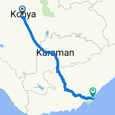
Alakova Çayırbağı Turu
A cycling route starting in Konya, Konya Province, Republic of Türkiye.
Overview
About this route
- -:--
- Duration
- 45.9 km
- Distance
- 377 m
- Ascent
- 375 m
- Descent
- ---
- Avg. speed
- 1,290 m
- Max. altitude

Route quality
Waytypes & surfaces along the route
Waytypes
Road
17.9 km
(39 %)
Cycleway
12.4 km
(27 %)
Surfaces
Paved
0.5 km
(1 %)
Asphalt
0.5 km
(1 %)
Undefined
45.4 km
(99 %)
Continue with Bikemap
Use, edit, or download this cycling route
You would like to ride Alakova Çayırbağı Turu or customize it for your own trip? Here is what you can do with this Bikemap route:
Free features
- Save this route as favorite or in collections
- Copy & plan your own version of this route
- Sync your route with Garmin or Wahoo
Premium features
Free trial for 3 days, or one-time payment. More about Bikemap Premium.
- Navigate this route on iOS & Android
- Export a GPX / KML file of this route
- Create your custom printout (try it for free)
- Download this route for offline navigation
Discover more Premium features.
Get Bikemap PremiumFrom our community
Other popular routes starting in Konya
 Kızılören-Sefaköy Turu
- Distance
- 80 km
- Ascent
- 972 m
- Descent
- 973 m
- Location
- Konya, Konya Province, Republic of Türkiye
 Kent Ormanı Piknik Turu (Yol Bisiklet Güzergahı)
- Distance
- 27.5 km
- Ascent
- 706 m
- Descent
- 255 m
- Location
- Konya, Konya Province, Republic of Türkiye
 Hatunsaray-Kavak-Boyalı turu
- Distance
- 80.4 km
- Ascent
- 669 m
- Descent
- 670 m
- Location
- Konya, Konya Province, Republic of Türkiye
 Kent Ormanı Piknik Turu (MTB Bisiklet Güzergahı)
- Distance
- 27.1 km
- Ascent
- 541 m
- Descent
- 90 m
- Location
- Konya, Konya Province, Republic of Türkiye
 konya-silifke
- Distance
- 271.6 km
- Ascent
- 2,446 m
- Descent
- 3,474 m
- Location
- Konya, Konya Province, Republic of Türkiye
 Emir Seyfettin Sokak to Hükümet Caddesi
- Distance
- 11.7 km
- Ascent
- 200 m
- Descent
- 90 m
- Location
- Konya, Konya Province, Republic of Türkiye
 Kilistra Turu-Meram Bld önünden
- Distance
- 95.8 km
- Ascent
- 1,265 m
- Descent
- 1,265 m
- Location
- Konya, Konya Province, Republic of Türkiye
 Kent Ormanı Turu
- Distance
- 41 km
- Ascent
- 882 m
- Descent
- 881 m
- Location
- Konya, Konya Province, Republic of Türkiye
Open it in the app