

radosna wycieczka za miasto ;)
A cycling route starting in Ochota, Masovian Voivodeship, Poland.
Overview
About this route
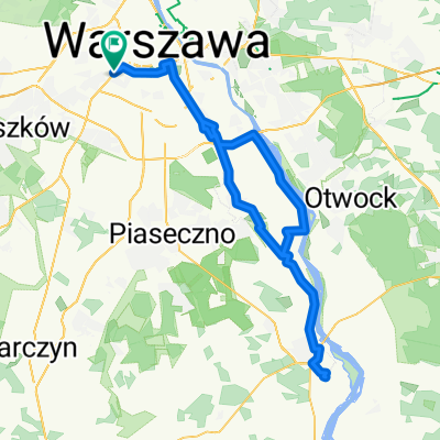
Warsaw - Jabłonna - Nowy Dwór - Błonie - Warsaw
- -:--
- Duration
- 103.4 km
- Distance
- 77 m
- Ascent
- 92 m
- Descent
- ---
- Avg. speed
- ---
- Max. altitude
Continue with Bikemap
Use, edit, or download this cycling route
You would like to ride radosna wycieczka za miasto ;) or customize it for your own trip? Here is what you can do with this Bikemap route:
Free features
- Save this route as favorite or in collections
- Copy & plan your own version of this route
- Split it into stages to create a multi-day tour
- Sync your route with Garmin or Wahoo
Premium features
Free trial for 3 days, or one-time payment. More about Bikemap Premium.
- Navigate this route on iOS & Android
- Export a GPX / KML file of this route
- Create your custom printout (try it for free)
- Download this route for offline navigation
Discover more Premium features.
Get Bikemap PremiumFrom our community
Other popular routes starting in Ochota
 Barska do Barska 11/13
- Distance
- 1.8 km
- Ascent
- 22 m
- Descent
- 71 m
- Location
- Ochota, Masovian Voivodeship, Poland
 Opaczewska 65, Warszawa do Opaczewska 65, Warszawa
- Distance
- 48.1 km
- Ascent
- 163 m
- Descent
- 204 m
- Location
- Ochota, Masovian Voivodeship, Poland
 radosna wycieczka za miasto ;)
- Distance
- 103.4 km
- Ascent
- 77 m
- Descent
- 92 m
- Location
- Ochota, Masovian Voivodeship, Poland
 Białobrzeska do Białobrzeska
- Distance
- 19.4 km
- Ascent
- 1,327 m
- Descent
- 1,341 m
- Location
- Ochota, Masovian Voivodeship, Poland
 Trening z Rafałem Majką 17.10.2015
- Distance
- 58.8 km
- Ascent
- 24 m
- Descent
- 26 m
- Location
- Ochota, Masovian Voivodeship, Poland
 Decathlon Reduta do Decathlon Reduta
- Distance
- 96.1 km
- Ascent
- 188 m
- Descent
- 188 m
- Location
- Ochota, Masovian Voivodeship, Poland
 Barska do Białobrzeska
- Distance
- 9.2 km
- Ascent
- 80 m
- Descent
- 125 m
- Location
- Ochota, Masovian Voivodeship, Poland
 warka grojec
- Distance
- 138 km
- Ascent
- 165 m
- Descent
- 166 m
- Location
- Ochota, Masovian Voivodeship, Poland
Open it in the app