

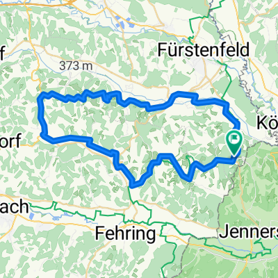
Dietersdorf bis Kopar
A cycling route starting in Loipersdorf bei Fürstenfeld, Styria, Austria.
Overview
About this route
- -:--
- Duration
- 447.4 km
- Distance
- 5,914 m
- Ascent
- 6,153 m
- Descent
- ---
- Avg. speed
- 892 m
- Max. altitude

Route quality
Waytypes & surfaces along the route
Waytypes
Quiet road
165.5 km
(37 %)
Road
129.7 km
(29 %)
Surfaces
Paved
308.7 km
(69 %)
Unpaved
35.8 km
(8 %)
Asphalt
299.7 km
(67 %)
Gravel
26.8 km
(6 %)
Continue with Bikemap
Use, edit, or download this cycling route
You would like to ride Dietersdorf bis Kopar or customize it for your own trip? Here is what you can do with this Bikemap route:
Free features
- Save this route as favorite or in collections
- Copy & plan your own version of this route
- Split it into stages to create a multi-day tour
- Sync your route with Garmin or Wahoo
Premium features
Free trial for 3 days, or one-time payment. More about Bikemap Premium.
- Navigate this route on iOS & Android
- Export a GPX / KML file of this route
- Create your custom printout (try it for free)
- Download this route for offline navigation
Discover more Premium features.
Get Bikemap PremiumFrom our community
Other popular routes starting in Loipersdorf bei Fürstenfeld
 4 Elemente Tour LUFT 1 im Thermen- & Vulkanland Steiermark
- Distance
- 62.6 km
- Ascent
- 705 m
- Descent
- 705 m
- Location
- Loipersdorf bei Fürstenfeld, Styria, Austria
 Lafnitz /Rudersdorf/Jennersdorf
- Distance
- 47.3 km
- Ascent
- 188 m
- Descent
- 186 m
- Location
- Loipersdorf bei Fürstenfeld, Styria, Austria
 4 Elemente Tour LUFT 1 im Thermen- & Vulkanland Steiermark - 4 Elemente Tour LUFT 1 im Thermen- & Vulkanland Steiermark
- Distance
- 63.3 km
- Ascent
- 888 m
- Descent
- 889 m
- Location
- Loipersdorf bei Fürstenfeld, Styria, Austria
 Loipersdorf Runde
- Distance
- 41.4 km
- Ascent
- 325 m
- Descent
- 328 m
- Location
- Loipersdorf bei Fürstenfeld, Styria, Austria
 Loipersdorf-Riegersburg Runde
- Distance
- 45.1 km
- Ascent
- 446 m
- Descent
- 446 m
- Location
- Loipersdorf bei Fürstenfeld, Styria, Austria
 Apfelhöfe-Tour
- Distance
- 75 km
- Ascent
- 417 m
- Descent
- 413 m
- Location
- Loipersdorf bei Fürstenfeld, Styria, Austria
 Schaffelbadstraße 220, Loipersdorf bei Fürstenfeld nach Schaffelbadstraße 220, Loipersdorf bei Fürstenfeld
- Distance
- 25.6 km
- Ascent
- 385 m
- Descent
- 390 m
- Location
- Loipersdorf bei Fürstenfeld, Styria, Austria
 Riegersburgtour
- Distance
- 91.2 km
- Ascent
- 859 m
- Descent
- 858 m
- Location
- Loipersdorf bei Fürstenfeld, Styria, Austria
Open it in the app