

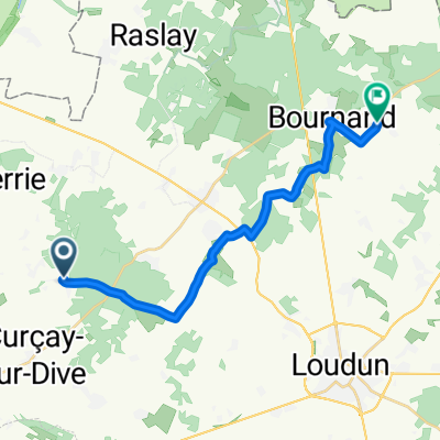
3 Route de Ranton, Curçay-sur-Dive à Brion-près-Thouet
A cycling route starting in Saint-Léger-de-Montbrun, Nouvelle-Aquitaine, France.
Overview
About this route
- 50 min
- Duration
- 14.2 km
- Distance
- 118 m
- Ascent
- 189 m
- Descent
- 17.1 km/h
- Avg. speed
- 114 m
- Max. altitude
Route quality
Waytypes & surfaces along the route
Waytypes
Quiet road
7.4 km
(52 %)
Busy road
3.4 km
(24 %)
Surfaces
Paved
1.6 km
(12 %)
Asphalt
1.6 km
(12 %)
Undefined
12.5 km
(88 %)
Continue with Bikemap
Use, edit, or download this cycling route
You would like to ride 3 Route de Ranton, Curçay-sur-Dive à Brion-près-Thouet or customize it for your own trip? Here is what you can do with this Bikemap route:
Free features
- Save this route as favorite or in collections
- Copy & plan your own version of this route
- Sync your route with Garmin or Wahoo
Premium features
Free trial for 3 days, or one-time payment. More about Bikemap Premium.
- Navigate this route on iOS & Android
- Export a GPX / KML file of this route
- Create your custom printout (try it for free)
- Download this route for offline navigation
Discover more Premium features.
Get Bikemap PremiumFrom our community
Other popular routes starting in Saint-Léger-de-Montbrun
 Rue du Château do D23
- Distance
- 17.4 km
- Ascent
- 68 m
- Descent
- 165 m
- Location
- Saint-Léger-de-Montbrun, Nouvelle-Aquitaine, France
 9 Rue du Château, Ternay à 5 Boulevard Raymond Vouhé, Thouars
- Distance
- 21.9 km
- Ascent
- 132 m
- Descent
- 134 m
- Location
- Saint-Léger-de-Montbrun, Nouvelle-Aquitaine, France
 B-1000 RAA 2021
- Distance
- 239.2 km
- Ascent
- 1,337 m
- Descent
- 1,414 m
- Location
- Saint-Léger-de-Montbrun, Nouvelle-Aquitaine, France
 3 Route de Ranton, Curçay-sur-Dive à Brion-près-Thouet
- Distance
- 14.2 km
- Ascent
- 118 m
- Descent
- 189 m
- Location
- Saint-Léger-de-Montbrun, Nouvelle-Aquitaine, France
Open it in the app