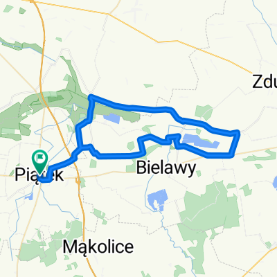
Tama wodna w lesie przy G艂贸wnej w Giecznie
A cycling route starting in Gmina Pi膮tek, 艁贸d藕 Voivodeship, Poland.
Overview
About this route
- 2 h 13 min
- Duration
- 23.6 km
- Distance
- 76 m
- Ascent
- 77 m
- Descent
- 10.7 km/h
- Avg. speed
- 130 m
- Avg. speed
Route photos
Route quality
Waytypes & surfaces along the route
Waytypes
Quiet road
17.7 km
(75 %)
Road
4 km
(17 %)
Surfaces
Paved
18.4 km
(78 %)
Asphalt
18.4 km
(78 %)
Undefined
5.1 km
(22 %)
Continue with Bikemap
Use, edit, or download this cycling route
You would like to ride Tama wodna w lesie przy G艂贸wnej w Giecznie or customize it for your own trip? Here is what you can do with this Bikemap route:
Free features
- Save this route as favorite or in collections
- Copy & plan your own version of this route
- Sync your route with Garmin or Wahoo
Premium features
Free trial for 3 days, or one-time payment. More about Bikemap Premium.
- Navigate this route on iOS & Android
- Export a GPX / KML file of this route
- Create your custom printout (try it for free)
- Download this route for offline navigation
Discover more Premium features.
Get Bikemap PremiumFrom our community
Other popular routes starting in Gmina Pi膮tek
- Su艂kowice Pierwsze 40, Pi膮tek do Su艂kowice Pierwsze 40, Pi膮tek
- Distance
- 27.3 km
- Ascent
- 52 m
- Descent
- 53 m
- Location
- Gmina Pi膮tek, 艁贸d藕 Voivodeship, Poland
- Starych Drzew
- Distance
- 50.8 km
- Ascent
- 82 m
- Descent
- 81 m
- Location
- Gmina Pi膮tek, 艁贸d藕 Voivodeship, Poland
- 艁ysa G贸ra
- Distance
- 14.4 km
- Ascent
- 25 m
- Descent
- 25 m
- Location
- Gmina Pi膮tek, 艁贸d藕 Voivodeship, Poland
- Tama wodna w lesie przy G艂贸wnej w Giecznie
- Distance
- 23.6 km
- Ascent
- 76 m
- Descent
- 77 m
- Location
- Gmina Pi膮tek, 艁贸d藕 Voivodeship, Poland
- Tour de Los 2018
- Distance
- 1,926.6 km
- Ascent
- 811 m
- Descent
- 800 m
- Location
- Gmina Pi膮tek, 艁贸d藕 Voivodeship, Poland
- Tour de Pi膮tek (偶贸艂ty)-zmodyfikowany 2014
- Distance
- 44.1 km
- Ascent
- 62 m
- Descent
- 63 m
- Location
- Gmina Pi膮tek, 艁贸d藕 Voivodeship, Poland
- Pi膮tek-sobota-pi膮tek
- Distance
- 53.3 km
- Ascent
- 38 m
- Descent
- 38 m
- Location
- Gmina Pi膮tek, 艁贸d藕 Voivodeship, Poland
- Kutnowska 68, Pi膮tek do Kutnowska 66, Pi膮tek
- Distance
- 18.7 km
- Ascent
- 63 m
- Descent
- 78 m
- Location
- Gmina Pi膮tek, 艁贸d藕 Voivodeship, Poland
Open it in the app