
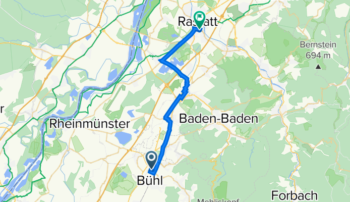
Bühl nach Rastatt Hopfenschlingel
A cycling route starting in Bühl, Baden-Württemberg, Germany.
Overview
About this route
- 1 h 23 min
- Duration
- 23.6 km
- Distance
- 58 m
- Ascent
- 71 m
- Descent
- 17 km/h
- Avg. speed
- 137 m
- Avg. speed

Route quality
Waytypes & surfaces along the route
Waytypes
Path
13.4 km
(57 %)
Track
5.7 km
(24 %)
Surfaces
Paved
19.5 km
(82 %)
Unpaved
0.3 km
(1 %)
Asphalt
16.4 km
(70 %)
Paved (undefined)
2.4 km
(10 %)
Continue with Bikemap
Use, edit, or download this cycling route
You would like to ride Bühl nach Rastatt Hopfenschlingel or customize it for your own trip? Here is what you can do with this Bikemap route:
Free features
- Save this route as favorite or in collections
- Copy & plan your own version of this route
- Sync your route with Garmin or Wahoo
Premium features
Free trial for 3 days, or one-time payment. More about Bikemap Premium.
- Navigate this route on iOS & Android
- Export a GPX / KML file of this route
- Create your custom printout (try it for free)
- Download this route for offline navigation
Discover more Premium features.
Get Bikemap PremiumFrom our community
Other popular routes starting in Bühl
 R -> T über Neusatz & Rote Lache
- Distance
- 66.2 km
- Ascent
- 1,943 m
- Descent
- 1,939 m
- Location
- Bühl, Baden-Württemberg, Germany
 erster Versuch
- Distance
- 50.6 km
- Ascent
- 976 m
- Descent
- 976 m
- Location
- Bühl, Baden-Württemberg, Germany
 Nordschwarzwald-Rundfahrt 2021 - RTF des RSV Falkenfels Bühlertal e.V. 1913 - 82 km Strecke
- Distance
- 77.7 km
- Ascent
- 108 m
- Descent
- 110 m
- Location
- Bühl, Baden-Württemberg, Germany
 Bühlertaler Radsonntag Familientour 28km
- Distance
- 27.1 km
- Ascent
- 58 m
- Descent
- 60 m
- Location
- Bühl, Baden-Württemberg, Germany
 Tour Sessenheim Radwochenende SWAZ 09
- Distance
- 73.9 km
- Ascent
- 65 m
- Descent
- 73 m
- Location
- Bühl, Baden-Württemberg, Germany
 Nordschwarzwald-Rundfahrt 2021 - RTF des RSV Falkenfels Bühlertal e.V. 1913 - 55 km Strecke
- Distance
- 54 km
- Ascent
- 15 m
- Descent
- 17 m
- Location
- Bühl, Baden-Württemberg, Germany
 2020 RS 02-unter194er planen
- Distance
- 194.4 km
- Ascent
- 2,480 m
- Descent
- 2,480 m
- Location
- Bühl, Baden-Württemberg, Germany
 Hornisgrinde
- Distance
- 39.9 km
- Ascent
- 1,051 m
- Descent
- 1,051 m
- Location
- Bühl, Baden-Württemberg, Germany
Open it in the app