

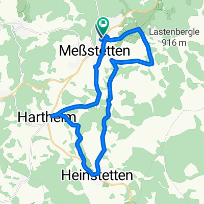
Hochalb-Tour - Auf den Höhen Meßstettens
A cycling route starting in Meßstetten, Baden-Wurttemberg, Germany.
Overview
About this route
A tour that delivers on its promises - heights to climb and plains to enjoy.
- -:--
- Duration
- 43.2 km
- Distance
- 806 m
- Ascent
- 804 m
- Descent
- ---
- Avg. speed
- 976 m
- Max. altitude
Route quality
Waytypes & surfaces along the route
Waytypes
Quiet road
17.7 km
(41 %)
Track
17.7 km
(41 %)
Surfaces
Paved
27.6 km
(64 %)
Unpaved
4.3 km
(10 %)
Asphalt
21.6 km
(50 %)
Paved (undefined)
6 km
(14 %)
Continue with Bikemap
Use, edit, or download this cycling route
You would like to ride Hochalb-Tour - Auf den Höhen Meßstettens or customize it for your own trip? Here is what you can do with this Bikemap route:
Free features
- Save this route as favorite or in collections
- Copy & plan your own version of this route
- Sync your route with Garmin or Wahoo
Premium features
Free trial for 3 days, or one-time payment. More about Bikemap Premium.
- Navigate this route on iOS & Android
- Export a GPX / KML file of this route
- Create your custom printout (try it for free)
- Download this route for offline navigation
Discover more Premium features.
Get Bikemap PremiumFrom our community
Other popular routes starting in Meßstetten
 Albstadt Laufen - Mössingen/Öschingen
- Distance
- 46.5 km
- Ascent
- 1,085 m
- Descent
- 1,103 m
- Location
- Meßstetten, Baden-Wurttemberg, Germany
 Meßstetten-Tieringen-Heidenhof-ODH-UDH-HH-M
- Distance
- 29.6 km
- Ascent
- 466 m
- Descent
- 475 m
- Location
- Meßstetten, Baden-Wurttemberg, Germany
 20210415 Meßst._Heinst._Harth.
- Distance
- 18.9 km
- Ascent
- 246 m
- Descent
- 237 m
- Location
- Meßstetten, Baden-Wurttemberg, Germany
 Lockere Tour durch den Zollernalbkreis
- Distance
- 64.6 km
- Ascent
- 1,079 m
- Descent
- 1,034 m
- Location
- Meßstetten, Baden-Wurttemberg, Germany
 Hartheim-Stetten-Albstadt-Meßstetten-Hartheim
- Distance
- 54 km
- Ascent
- 533 m
- Descent
- 532 m
- Location
- Meßstetten, Baden-Wurttemberg, Germany
 Hochalb-Tour - Auf den Höhen Meßstettens
- Distance
- 43.2 km
- Ascent
- 806 m
- Descent
- 804 m
- Location
- Meßstetten, Baden-Wurttemberg, Germany
 Meßstetten- Harth.-Udi,Odi,Tie,Laufen,Lautl. Meßstetten
- Distance
- 29.9 km
- Ascent
- 549 m
- Descent
- 548 m
- Location
- Meßstetten, Baden-Wurttemberg, Germany
 Torfelsen
- Distance
- 14.6 km
- Ascent
- 383 m
- Descent
- 365 m
- Location
- Meßstetten, Baden-Wurttemberg, Germany
Open it in the app