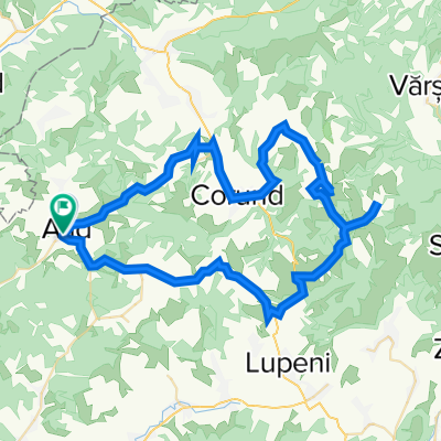
20220511_Etéd_Fenyőkút_Szencsed_Pálpataka
A cycling route starting in Atid, Harghita, Romania.
Overview
About this route
Látnivalók:
Atyha - római katolikus templom
Korond: kínai ócskaságok tárháza
Korond: Csigadomb
Fenyőkút: tőzegláp
Szencsed: nárciszmező
Énlaka: unitárius templom - műemlék
- -:--
- Duration
- 67.4 km
- Distance
- 1,187 m
- Ascent
- 1,190 m
- Descent
- ---
- Avg. speed
- 989 m
- Avg. speed
Route quality
Waytypes & surfaces along the route
Waytypes
Road
31.6 km
(47 %)
Quiet road
18.8 km
(28 %)
Surfaces
Paved
35.3 km
(52 %)
Unpaved
19.3 km
(29 %)
Asphalt
35.3 km
(52 %)
Ground
11.9 km
(18 %)
Continue with Bikemap
Use, edit, or download this cycling route
You would like to ride 20220511_Etéd_Fenyőkút_Szencsed_Pálpataka or customize it for your own trip? Here is what you can do with this Bikemap route:
Free features
- Save this route as favorite or in collections
- Copy & plan your own version of this route
- Sync your route with Garmin or Wahoo
Premium features
Free trial for 3 days, or one-time payment. More about Bikemap Premium.
- Navigate this route on iOS & Android
- Export a GPX / KML file of this route
- Create your custom printout (try it for free)
- Download this route for offline navigation
Discover more Premium features.
Get Bikemap PremiumFrom our community
Other popular routes starting in Atid
- 20220511_Etéd_Fenyőkút_Szencsed_Pálpataka
- Distance
- 67.4 km
- Ascent
- 1,187 m
- Descent
- 1,190 m
- Location
- Atid, Harghita, Romania
- Udvarhelyszék - 6. nap
- Distance
- 37.8 km
- Ascent
- 620 m
- Descent
- 616 m
- Location
- Atid, Harghita, Romania
- Siklód
- Distance
- 47 km
- Ascent
- 974 m
- Descent
- 963 m
- Location
- Atid, Harghita, Romania
- Keresztúr
- Distance
- 53.9 km
- Ascent
- 479 m
- Descent
- 478 m
- Location
- Atid, Harghita, Romania
- 2.nap Gurul
- Distance
- 50.2 km
- Ascent
- 371 m
- Descent
- 242 m
- Location
- Atid, Harghita, Romania
- Eted Narcisz
- Distance
- 85.5 km
- Ascent
- 1,499 m
- Descent
- 1,499 m
- Location
- Atid, Harghita, Romania
- Udvarhelyszék - 7. nap
- Distance
- 41.1 km
- Ascent
- 759 m
- Descent
- 556 m
- Location
- Atid, Harghita, Romania
- Udvarhelyszék - 5. nap
- Distance
- 45.8 km
- Ascent
- 1,062 m
- Descent
- 916 m
- Location
- Atid, Harghita, Romania
Open it in the app