

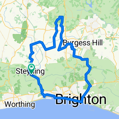
South Downs Way Pt3
A cycling route starting in Steyning, England, United Kingdom.
Overview
About this route
null
- -:--
- Duration
- 61.5 km
- Distance
- 1,377 m
- Ascent
- 1,354 m
- Descent
- ---
- Avg. speed
- 240 m
- Max. altitude

Route quality
Waytypes & surfaces along the route
Waytypes
Cycleway
40.6 km
(66 %)
Track
12.3 km
(20 %)
Surfaces
Paved
6.1 km
(10 %)
Unpaved
27.1 km
(44 %)
Unpaved (undefined)
19.1 km
(31 %)
Asphalt
4.9 km
(8 %)
Continue with Bikemap
Use, edit, or download this cycling route
You would like to ride South Downs Way Pt3 or customize it for your own trip? Here is what you can do with this Bikemap route:
Free features
- Save this route as favorite or in collections
- Copy & plan your own version of this route
- Sync your route with Garmin or Wahoo
Premium features
Free trial for 3 days, or one-time payment. More about Bikemap Premium.
- Navigate this route on iOS & Android
- Export a GPX / KML file of this route
- Create your custom printout (try it for free)
- Download this route for offline navigation
Discover more Premium features.
Get Bikemap PremiumFrom our community
Other popular routes starting in Steyning
 Old route
- Distance
- 21.9 km
- Ascent
- 144 m
- Descent
- 157 m
- Location
- Steyning, England, United Kingdom
 George's loop (with Mill Hill)
- Distance
- 33.1 km
- Ascent
- 388 m
- Descent
- 389 m
- Location
- Steyning, England, United Kingdom
 yeah boi
- Distance
- 86.3 km
- Ascent
- 368 m
- Descent
- 366 m
- Location
- Steyning, England, United Kingdom
 spicy
spicy- Distance
- 30.9 km
- Ascent
- 144 m
- Descent
- 148 m
- Location
- Steyning, England, United Kingdom
 Candytuft, High St, Steyning to Station Approach, Shoreham-By-Sea
- Distance
- 11.1 km
- Ascent
- 118 m
- Descent
- 116 m
- Location
- Steyning, England, United Kingdom
 Fletchers Croft to Fletchers Croft
- Distance
- 27.4 km
- Ascent
- 104 m
- Descent
- 99 m
- Location
- Steyning, England, United Kingdom
 South Downs Way Pt3
- Distance
- 61.5 km
- Ascent
- 1,377 m
- Descent
- 1,354 m
- Location
- Steyning, England, United Kingdom
 sdw8
sdw8- Distance
- 15 km
- Ascent
- 474 m
- Descent
- 372 m
- Location
- Steyning, England, United Kingdom
Open it in the app