

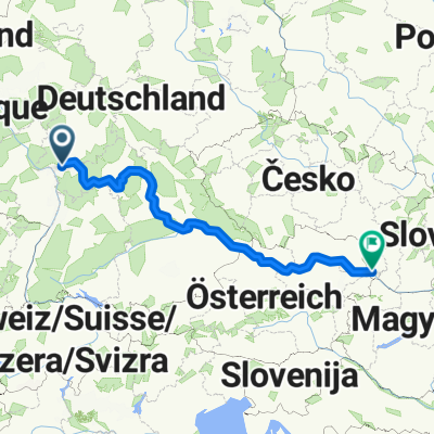
Friedrich-Ebert-Straße 24, Kelsterbach nach Straße ohne Straßennamen, Rüsselsheim am Main
A cycling route starting in Kelsterbach, Hesse, Germany.
Overview
About this route
- 37 min
- Duration
- 9.7 km
- Distance
- 44 m
- Ascent
- 44 m
- Descent
- 15.8 km/h
- Avg. speed
- 111 m
- Max. altitude

Route quality
Waytypes & surfaces along the route
Waytypes
Track
4.3 km
(45 %)
Path
3.5 km
(36 %)
Surfaces
Paved
5.3 km
(55 %)
Unpaved
4.4 km
(45 %)
Asphalt
5.3 km
(55 %)
Gravel
2.4 km
(25 %)
Continue with Bikemap
Use, edit, or download this cycling route
You would like to ride Friedrich-Ebert-Straße 24, Kelsterbach nach Straße ohne Straßennamen, Rüsselsheim am Main or customize it for your own trip? Here is what you can do with this Bikemap route:
Free features
- Save this route as favorite or in collections
- Copy & plan your own version of this route
- Sync your route with Garmin or Wahoo
Premium features
Free trial for 3 days, or one-time payment. More about Bikemap Premium.
- Navigate this route on iOS & Android
- Export a GPX / KML file of this route
- Create your custom printout (try it for free)
- Download this route for offline navigation
Discover more Premium features.
Get Bikemap PremiumFrom our community
Other popular routes starting in Kelsterbach
 Kleine Feierabendrunde
- Distance
- 46.2 km
- Ascent
- 380 m
- Descent
- 379 m
- Location
- Kelsterbach, Hesse, Germany
 schwanheim lauf
- Distance
- 9.5 km
- Ascent
- 39 m
- Descent
- 39 m
- Location
- Kelsterbach, Hesse, Germany
 Rundweg um den Frankfurter Flughafen CLONED FROM ROUTE 298299
- Distance
- 41.8 km
- Ascent
- 77 m
- Descent
- 76 m
- Location
- Kelsterbach, Hesse, Germany
 Frankfurt Höchst - Neu Isenburg - Offenbach - Runde
- Distance
- 58.9 km
- Ascent
- 293 m
- Descent
- 294 m
- Location
- Kelsterbach, Hesse, Germany
 RundwegAirportFfmWest-Worfelden
- Distance
- 34.8 km
- Ascent
- 69 m
- Descent
- 67 m
- Location
- Kelsterbach, Hesse, Germany
 Rüsselsheimer Str, Kelsterbach nach Frankfurter Straße 31, Offenbach am Main
- Distance
- 27.2 km
- Ascent
- 10 m
- Descent
- 14 m
- Location
- Kelsterbach, Hesse, Germany
 Leunabrücke Höchst nach Mainz
- Distance
- 28.3 km
- Ascent
- 31 m
- Descent
- 38 m
- Location
- Kelsterbach, Hesse, Germany
 From Frankfurt am Main to Saal an der Donau
- Distance
- 1,055 km
- Ascent
- 6,222 m
- Descent
- 6,196 m
- Location
- Kelsterbach, Hesse, Germany
Open it in the app