

Training Wales C1
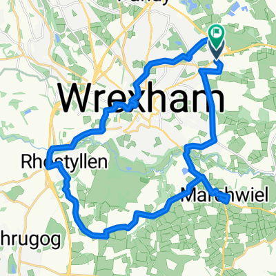
A cycling route starting in Wrexham, Wales, United Kingdom.
Overview
About this route
1
Auf einigen Abschnitten könnte die Straße besser sein, aber in der Regel kann man gut fahren. Zum Horseshoepass geht es mitunter bis zu 20% bergauf. An der höchsten Stelle liegt ein kleines Café wo man einkehren könnte. Weiterhin beginnen dort zwei Wanderwege die hinauf zu den angrenzenden Bergen führen. Selbst mit dem Mountainbike ist die Steigung dort größtenteils zu hoch, so dass man das Bike am Café lässt oder gezwungen ist den größten Teil der Strecke zu schieben.
1050 Hm für die Strecke
1380 Hm mit Abstecher zum "Moel y Gamelin"
- -:--
- Duration
- 53.8 km
- Distance
- 579 m
- Ascent
- 577 m
- Descent
- ---
- Avg. speed
- ---
- Max. altitude
Oranje
created this 14 years ago
Route quality
Waytypes & surfaces along the route
Waytypes
Quiet road
2.7 km
5 %
Access road
1.1 km
2 %
Undefined
50 km
93 %
Surfaces
Paved
34.9 km
(65 %)
Asphalt
25.3 km
47 %
Paved (undefined)
9.7 km
18 %
Undefined
18.8 km
35 %
Continue with Bikemap
Use, edit, or download this cycling route
You would like to ride Training Wales C1 or customize it for your own trip? Here is what you can do with this Bikemap route:
Free features
- Save this route as favorite or in collections
- Copy & plan your own version of this route
- Sync your route with Garmin or Wahoo
Premium features
Free trial for 3 days, or one-time payment. More about Bikemap Premium.
- Navigate this route on iOS & Android
- Export a GPX / KML file of this route
- Create your custom printout (try it for free)
- Download this route for offline navigation
Discover more Premium features.
Get Bikemap PremiumFrom our community
Other popular routes starting in Wrexham


Open it in the app