

Bad Sachsa am 6.10.07
A cycling route starting in Bad Lauterberg im Harz, Lower Saxony, Germany.
Overview
About this route
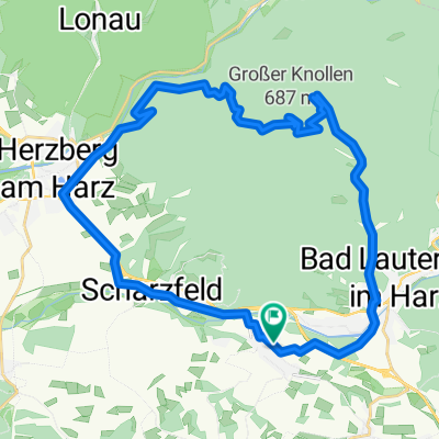
Bad Lauterberg - Wiesenbeckerteich - Koldung - Dreymannsmühle - Bartolfelde - Grenzweg !!Der Grenzweg ist teilweise die alte Postenstraße von NVA es sind Langlöcher in den Betonplatten in Fahrrichtung sturzgefahr! - Nüxei - Tettenborn - Bad Sachsa - Märchengrund - Ravensberg - Wasserscheide - 11km Weg - Bad Lauterberg
- -:--
- Duration
- 40.8 km
- Distance
- 777 m
- Ascent
- 777 m
- Descent
- ---
- Avg. speed
- ---
- Max. altitude
Continue with Bikemap
Use, edit, or download this cycling route
You would like to ride Bad Sachsa am 6.10.07 or customize it for your own trip? Here is what you can do with this Bikemap route:
Free features
- Save this route as favorite or in collections
- Copy & plan your own version of this route
- Sync your route with Garmin or Wahoo
Premium features
Free trial for 3 days, or one-time payment. More about Bikemap Premium.
- Navigate this route on iOS & Android
- Export a GPX / KML file of this route
- Create your custom printout (try it for free)
- Download this route for offline navigation
Discover more Premium features.
Get Bikemap PremiumFrom our community
Other popular routes starting in Bad Lauterberg im Harz
 Bad Sachsa am 6.10.07
- Distance
- 40.8 km
- Ascent
- 777 m
- Descent
- 777 m
- Location
- Bad Lauterberg im Harz, Lower Saxony, Germany
 D-Harz-BadL-125 2000 HDL
- Distance
- 126.4 km
- Ascent
- 1,295 m
- Descent
- 1,294 m
- Location
- Bad Lauterberg im Harz, Lower Saxony, Germany
 Barbis - Hanskühnenburg -Oderteich - Barbis
- Distance
- 67.1 km
- Ascent
- 776 m
- Descent
- 770 m
- Location
- Bad Lauterberg im Harz, Lower Saxony, Germany
 Rundtour, Bad Lauterberg-Bad Sachsa-Ravensberg
- Distance
- 31.1 km
- Ascent
- 785 m
- Descent
- 782 m
- Location
- Bad Lauterberg im Harz, Lower Saxony, Germany
 Runde zum Gr.Knollen
- Distance
- 26.6 km
- Ascent
- 618 m
- Descent
- 576 m
- Location
- Bad Lauterberg im Harz, Lower Saxony, Germany
 Barbis - Großer Knollen - Barbis
- Distance
- 31.5 km
- Ascent
- 524 m
- Descent
- 521 m
- Location
- Bad Lauterberg im Harz, Lower Saxony, Germany
 Südharz-Marathon 100er Runde
- Distance
- 111.1 km
- Ascent
- 1,314 m
- Descent
- 1,264 m
- Location
- Bad Lauterberg im Harz, Lower Saxony, Germany
 Große Wurmbergrunde
- Distance
- 53.5 km
- Ascent
- 893 m
- Descent
- 893 m
- Location
- Bad Lauterberg im Harz, Lower Saxony, Germany
Open it in the app