

Zum Hackl Schorsch
A cycling route starting in Oberteuringen, Baden-Wurttemberg, Germany.
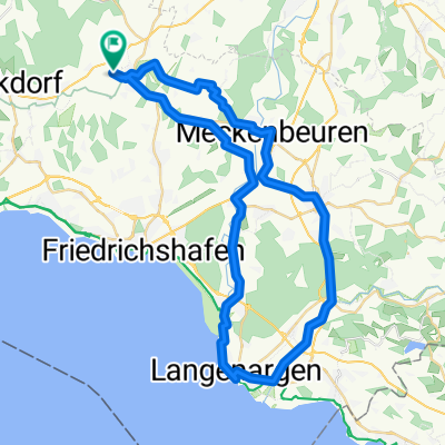
Overview
About this route
Ride over the Höchsten to Ilmensee, the Höchsten mountain route can be measured with the Stoppomat. In Ilmensee, stop at the beer garden of Hackl Schorsch.
- -:--
- Duration
- 21.3 km
- Distance
- 453 m
- Ascent
- 208 m
- Descent
- ---
- Avg. speed
- ---
- Max. altitude
Route highlights
Points of interest along the route
Point of interest after 7.4 km
Stoppomat - Start
Point of interest after 14.9 km
Höchsten
Point of interest after 20.5 km
Point of interest after 21.2 km
Continue with Bikemap
Use, edit, or download this cycling route
You would like to ride Zum Hackl Schorsch or customize it for your own trip? Here is what you can do with this Bikemap route:
Free features
- Save this route as favorite or in collections
- Copy & plan your own version of this route
- Sync your route with Garmin or Wahoo
Premium features
Free trial for 3 days, or one-time payment. More about Bikemap Premium.
- Navigate this route on iOS & Android
- Export a GPX / KML file of this route
- Create your custom printout (try it for free)
- Download this route for offline navigation
Discover more Premium features.
Get Bikemap PremiumFrom our community
Other popular routes starting in Oberteuringen
 Ailingen Bodnegg
- Distance
- 47.2 km
- Ascent
- 374 m
- Descent
- 378 m
- Location
- Oberteuringen, Baden-Wurttemberg, Germany
 TOUR-Magazin "Argental"
- Distance
- 63.7 km
- Ascent
- 775 m
- Descent
- 792 m
- Location
- Oberteuringen, Baden-Wurttemberg, Germany
 Altshausen
- Distance
- 81.1 km
- Ascent
- 524 m
- Descent
- 527 m
- Location
- Oberteuringen, Baden-Wurttemberg, Germany
 TOUR-Magazin "Allgäu"
- Distance
- 77.5 km
- Ascent
- 896 m
- Descent
- 904 m
- Location
- Oberteuringen, Baden-Wurttemberg, Germany
 OT Langenargen
- Distance
- 49.1 km
- Ascent
- 175 m
- Descent
- 178 m
- Location
- Oberteuringen, Baden-Wurttemberg, Germany
 Linzgautour
- Distance
- 69.9 km
- Ascent
- 487 m
- Descent
- 501 m
- Location
- Oberteuringen, Baden-Wurttemberg, Germany
 Gehrenberg-Heiligenberg-Höchsten-Benistobel-Urbanstobel
- Distance
- 50.3 km
- Ascent
- 984 m
- Descent
- 983 m
- Location
- Oberteuringen, Baden-Wurttemberg, Germany
 Bodenseerunde
- Distance
- 255.7 km
- Ascent
- 396 m
- Descent
- 396 m
- Location
- Oberteuringen, Baden-Wurttemberg, Germany
Open it in the app