

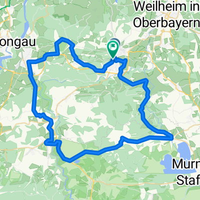
Zellerweg 12, Peißenberg nach Zellerweg 12, Peißenberg
A cycling route starting in Peißenberg, Bavaria, Germany.
Overview
About this route
- 1 h 44 min
- Duration
- 31.9 km
- Distance
- 474 m
- Ascent
- 478 m
- Descent
- 18.4 km/h
- Avg. speed
- 984 m
- Max. altitude

Route quality
Waytypes & surfaces along the route
Waytypes
Quiet road
14.7 km
(46 %)
Track
11.8 km
(37 %)
Surfaces
Paved
14 km
(44 %)
Unpaved
13.7 km
(43 %)
Asphalt
13.4 km
(42 %)
Gravel
10.2 km
(32 %)
Continue with Bikemap
Use, edit, or download this cycling route
You would like to ride Zellerweg 12, Peißenberg nach Zellerweg 12, Peißenberg or customize it for your own trip? Here is what you can do with this Bikemap route:
Free features
- Save this route as favorite or in collections
- Copy & plan your own version of this route
- Sync your route with Garmin or Wahoo
Premium features
Free trial for 3 days, or one-time payment. More about Bikemap Premium.
- Navigate this route on iOS & Android
- Export a GPX / KML file of this route
- Create your custom printout (try it for free)
- Download this route for offline navigation
Discover more Premium features.
Get Bikemap PremiumFrom our community
Other popular routes starting in Peißenberg
 Wörther Straße 12A, Peißenberg nach Wörther Straße 12A, Peißenberg
- Distance
- 28.2 km
- Ascent
- 430 m
- Descent
- 413 m
- Location
- Peißenberg, Bavaria, Germany
 Hohenpeißenberg
- Distance
- 10.2 km
- Ascent
- 465 m
- Descent
- 462 m
- Location
- Peißenberg, Bavaria, Germany
 Tour zum Ausprobieren
- Distance
- 24.7 km
- Ascent
- 500 m
- Descent
- 490 m
- Location
- Peißenberg, Bavaria, Germany
 Moderate Route in Peißenberg
- Distance
- 25.8 km
- Ascent
- 84 m
- Descent
- 84 m
- Location
- Peißenberg, Bavaria, Germany
 Grubsee
- Distance
- 47 km
- Ascent
- 548 m
- Descent
- 545 m
- Location
- Peißenberg, Bavaria, Germany
 Peißenberg-Bad Bayersoien
- Distance
- 65.7 km
- Ascent
- 959 m
- Descent
- 954 m
- Location
- Peißenberg, Bavaria, Germany
 Mtb Runde von Peißenberg, Carl-Benz-Straße, über Ammerhöfe, runter zur Ammer und zurück
- Distance
- 18.3 km
- Ascent
- 261 m
- Descent
- 265 m
- Location
- Peißenberg, Bavaria, Germany
 Peißenberg-Schöffau
- Distance
- 63.1 km
- Ascent
- 916 m
- Descent
- 913 m
- Location
- Peißenberg, Bavaria, Germany
Open it in the app