
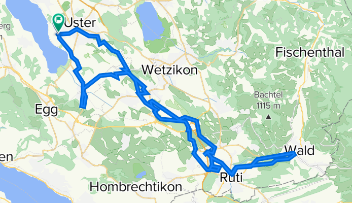
über Stock und Stein Uster - Wald Uster
A cycling route starting in Uster / Nieder-Uster, Canton of Zurich, Switzerland.
Overview
About this route
- 4 h
- Duration
- 58 km
- Distance
- 606 m
- Ascent
- 624 m
- Descent
- 14.5 km/h
- Avg. speed
- 649 m
- Max. altitude

Route quality
Waytypes & surfaces along the route
Waytypes
Quiet road
20.3 km
(35 %)
Track
16.2 km
(28 %)
Surfaces
Paved
41.8 km
(72 %)
Unpaved
13.3 km
(23 %)
Asphalt
40.6 km
(70 %)
Gravel
9.9 km
(17 %)
Continue with Bikemap
Use, edit, or download this cycling route
You would like to ride über Stock und Stein Uster - Wald Uster or customize it for your own trip? Here is what you can do with this Bikemap route:
Free features
- Save this route as favorite or in collections
- Copy & plan your own version of this route
- Sync your route with Garmin or Wahoo
Premium features
Free trial for 3 days, or one-time payment. More about Bikemap Premium.
- Navigate this route on iOS & Android
- Export a GPX / KML file of this route
- Create your custom printout (try it for free)
- Download this route for offline navigation
Discover more Premium features.
Get Bikemap PremiumFrom our community
Other popular routes starting in Uster / Nieder-Uster
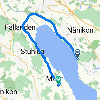
 Greifensee via Forch
- Distance
- 27.8 km
- Ascent
- 318 m
- Descent
- 316 m
- Location
- Uster / Nieder-Uster, Canton of Zurich, Switzerland
 Pfannenstiel Hochwacht
- Distance
- 10.7 km
- Ascent
- 386 m
- Descent
- 19 m
- Location
- Uster / Nieder-Uster, Canton of Zurich, Switzerland
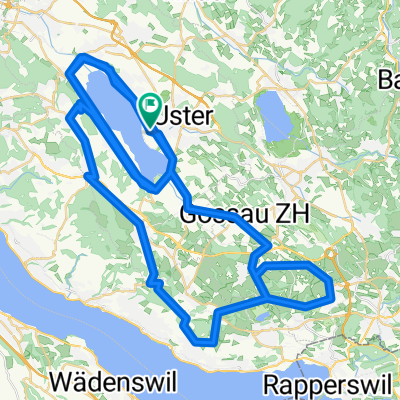
 Oberland Rundfahrt
- Distance
- 64.4 km
- Ascent
- 1,201 m
- Descent
- 1,201 m
- Location
- Uster / Nieder-Uster, Canton of Zurich, Switzerland
 Vorder Höhi-Hulftegg-Ghöch
- Distance
- 139 km
- Ascent
- 1,877 m
- Descent
- 1,875 m
- Location
- Uster / Nieder-Uster, Canton of Zurich, Switzerland
 Uster - Oberrohrdorf
- Distance
- 41.4 km
- Ascent
- 436 m
- Descent
- 402 m
- Location
- Uster / Nieder-Uster, Canton of Zurich, Switzerland
 über Stock und Stein Uster - Wald Uster
- Distance
- 58 km
- Ascent
- 606 m
- Descent
- 624 m
- Location
- Uster / Nieder-Uster, Canton of Zurich, Switzerland
 Moderate route in Maur
- Distance
- 11.3 km
- Ascent
- 64 m
- Descent
- 38 m
- Location
- Uster / Nieder-Uster, Canton of Zurich, Switzerland
 Uster Triathlon 2024 (Mitteldistanz)
- Distance
- 90.5 km
- Ascent
- 949 m
- Descent
- 947 m
- Location
- Uster / Nieder-Uster, Canton of Zurich, Switzerland
Open it in the app