

大豹溪擁抱自然鐵馬樂活遊
A cycling route starting in Taoyuan District, Taiwan, Taiwan.
Overview
About this route
報到時間:<span lang="EN-US">7 </span>月<span lang="EN-US"> 9 </span>日(六)上午<span lang="EN-US"> 8 </span>時
出發時間:<span lang="EN-US">7 </span>月<span lang="EN-US"> 9 </span>日(六)上午9時
報到地點:三峽清水祖師廟廟前廣場
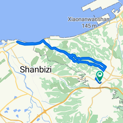
騎乘路線:<span lang="EN-US">(</span>起點<span lang="EN-US">)</span>三峽祖師廟<span lang="EN-US">-</span>台<span lang="EN-US"> 3 </span>線<span lang="EN-US">-</span>白雞路<span lang="EN-US">-</span>正義吊橋<span lang="EN-US">-</span>福利橋<span lang="EN-US">-</span>三峽溪<span lang="EN-US">-</span>北<span lang="EN-US"> 111 </span>鄉道<span lang="EN-US">-</span>湊合
十八洞天<span lang="EN-US">-</span>大板根溫泉<span lang="EN-US">-</span>大豹溪生態體驗<span lang="EN-US">-</span>滿月圓森林浴觀光健康樂活<span lang="EN-US">-</span>熊空奔馳
休閒<span lang="EN-US">(</span>折返點<span lang="EN-US">)-</span>返回三峽祖師廟。
蓋章點:滿月圓森林遊樂區牌樓
路線特色:大豹溪為淡水河源頭之一,屬雪山山脈的尾端,水量充沛、清澈無污染,由中
坑溪、蚋仔溪、熊空溪、東眼溪及水車寮溪所組成,在湊合橋與五寮溪匯合後
成為三峽溪。沿途行經三峽滿月圓森林遊憩區以及熊空休閒農場。
- -:--
- Duration
- 18.4 km
- Distance
- 478 m
- Ascent
- 164 m
- Descent
- ---
- Avg. speed
- ---
- Max. altitude

Route quality
Waytypes & surfaces along the route
Waytypes
Road
13.3 km
(72 %)
Access road
4 km
(22 %)
Surfaces
Paved
13.8 km
(75 %)
Asphalt
13.8 km
(75 %)
Undefined
4.6 km
(25 %)
Continue with Bikemap
Use, edit, or download this cycling route
You would like to ride 大豹溪擁抱自然鐵馬樂活遊 or customize it for your own trip? Here is what you can do with this Bikemap route:
Free features
- Save this route as favorite or in collections
- Copy & plan your own version of this route
- Sync your route with Garmin or Wahoo
Premium features
Free trial for 3 days, or one-time payment. More about Bikemap Premium.
- Navigate this route on iOS & Android
- Export a GPX / KML file of this route
- Create your custom printout (try it for free)
- Download this route for offline navigation
Discover more Premium features.
Get Bikemap PremiumFrom our community
Other popular routes starting in Taoyuan District
 樹琳大棟山
樹琳大棟山- Distance
- 4.4 km
- Ascent
- 369 m
- Descent
- 80 m
- Location
- Taoyuan District, Taiwan, Taiwan
 熊空茶園
熊空茶園- Distance
- 15.5 km
- Ascent
- 805 m
- Descent
- 146 m
- Location
- Taoyuan District, Taiwan, Taiwan
 羅馬公路自由行
- Distance
- 97.4 km
- Ascent
- 0 m
- Descent
- 0 m
- Location
- Taoyuan District, Taiwan, Taiwan
 大棟山
大棟山- Distance
- 33.7 km
- Ascent
- 1,130 m
- Descent
- 1,132 m
- Location
- Taoyuan District, Taiwan, Taiwan
 100.03.12 鶯歌到三坑 <慢騎cloub>
- Distance
- 43.1 km
- Ascent
- 224 m
- Descent
- 224 m
- Location
- Taoyuan District, Taiwan, Taiwan
 Linkou-林口 to Dayuan-大圓
- Distance
- 32.2 km
- Ascent
- 310 m
- Descent
- 310 m
- Location
- Taoyuan District, Taiwan, Taiwan
 鶯歌大榕樹
鶯歌大榕樹- Distance
- 22.2 km
- Ascent
- 637 m
- Descent
- 642 m
- Location
- Taoyuan District, Taiwan, Taiwan
 宇老滿貫
宇老滿貫- Distance
- 139.4 km
- Ascent
- 2,047 m
- Descent
- 2,051 m
- Location
- Taoyuan District, Taiwan, Taiwan
Open it in the app