

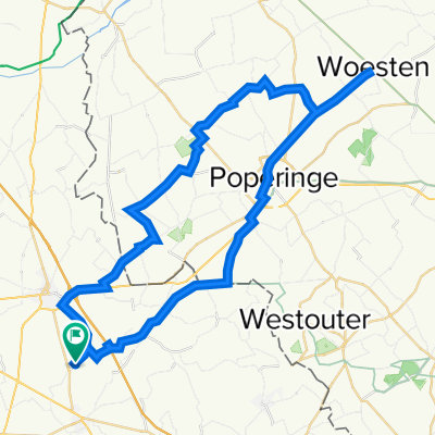
Beer and Memorial Route 2022
A cycling route starting in Caëstre, Hauts-de-France, France.
Overview
About this route
St Bernardus, Westvleteren, Deca, Struise, De Dolle, Passendaele
- -:--
- Duration
- 104.2 km
- Distance
- 349 m
- Ascent
- 381 m
- Descent
- ---
- Avg. speed
- 66 m
- Max. altitude

Route quality
Waytypes & surfaces along the route
Waytypes
Quiet road
57.3 km
(55 %)
Road
16.7 km
(16 %)
Surfaces
Paved
62.5 km
(60 %)
Unpaved
1 km
(1 %)
Asphalt
52.1 km
(50 %)
Concrete
9.4 km
(9 %)
Continue with Bikemap
Use, edit, or download this cycling route
You would like to ride Beer and Memorial Route 2022 or customize it for your own trip? Here is what you can do with this Bikemap route:
Free features
- Save this route as favorite or in collections
- Copy & plan your own version of this route
- Split it into stages to create a multi-day tour
- Sync your route with Garmin or Wahoo
Premium features
Free trial for 3 days, or one-time payment. More about Bikemap Premium.
- Navigate this route on iOS & Android
- Export a GPX / KML file of this route
- Create your custom printout (try it for free)
- Download this route for offline navigation
Discover more Premium features.
Get Bikemap PremiumFrom our community
Other popular routes starting in Caëstre
 De Voie Communale Hool Straete 126, Caëstre à Grand' Place 27, Cassel
- Distance
- 13.6 km
- Ascent
- 145 m
- Descent
- 38 m
- Location
- Caëstre, Hauts-de-France, France
 1417 Rue Nationale, Borre à 3 Place Publique, Monchy-au-Bois
- Distance
- 88.2 km
- Ascent
- 555 m
- Descent
- 447 m
- Location
- Caëstre, Hauts-de-France, France
 De Rue Cayonque 695, Borre à Chemin des Jeangrands 21, Arbigny
- Distance
- 643.9 km
- Ascent
- 3,341 m
- Descent
- 3,182 m
- Location
- Caëstre, Hauts-de-France, France
 Bike Ride & Beer with Soph
- Distance
- 49.4 km
- Ascent
- 262 m
- Descent
- 264 m
- Location
- Caëstre, Hauts-de-France, France
 647 Rue Nationale, Pradelles à 10 Rue de l'Église, Hazebrouck
- Distance
- 7.4 km
- Ascent
- 103 m
- Descent
- 106 m
- Location
- Caëstre, Hauts-de-France, France
 401–999 Route du Mont des Cats, Flêtre à 563 Rue Delannoy, Lestrem
- Distance
- 21 km
- Ascent
- 26 m
- Descent
- 60 m
- Location
- Caëstre, Hauts-de-France, France
 bike tour through Caëstre
- Distance
- 12.1 km
- Ascent
- 62 m
- Descent
- 60 m
- Location
- Caëstre, Hauts-de-France, France
 Beer and Memorial Route 2022
- Distance
- 104.2 km
- Ascent
- 349 m
- Descent
- 381 m
- Location
- Caëstre, Hauts-de-France, France
Open it in the app