
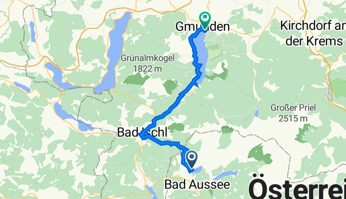
SKG lang 4: Fischerndorf-Gmunden; 53,3km 440hm
A cycling route starting in Altaussee, Styria, Austria.
Overview
About this route
Fischerndorf - Altaussee - (R61) - Sagbühel - Rettenbachalm - Reiterndorf - Bad Ischl - (R2) - Steinkogel - Ebensee - Traunkirchen - Winkl - Ebenzweier - Altmünster - Gmunden
Seehotel im Weyer, Traunsteinstraße 23, Gmunden
Altmünsterhof, Ackerweg 2, Altmünster am Traunsee
- -:--
- Duration
- 53.3 km
- Distance
- 673 m
- Ascent
- 975 m
- Descent
- ---
- Avg. speed
- 904 m
- Max. altitude

Route highlights
Points of interest along the route
Point of interest after 4.9 km
Blaa Alm

Point of interest after 6.7 km
Rettenbachklamm
Point of interest after 10 km
Rettenbachalm
Point of interest after 37.5 km
Sky Waterwalk
Point of interest after 40 km
Traunsee Löwe

Point of interest after 41.7 km
Blick Traunkirchen
Point of interest after 43 km
öffentlicher Badeplatz Imwinkl
Point of interest after 44.2 km
öffentliche Badestelle Bräuwiese

Point of interest after 51 km
Land- und Seeschloß Orth

Point of interest after 52.1 km
Gnom mit Bergkristall

Point of interest after 53 km
Badestelle Dracheninsel
Continue with Bikemap
Use, edit, or download this cycling route
You would like to ride SKG lang 4: Fischerndorf-Gmunden; 53,3km 440hm or customize it for your own trip? Here is what you can do with this Bikemap route:
Free features
- Save this route as favorite or in collections
- Copy & plan your own version of this route
- Sync your route with Garmin or Wahoo
Premium features
Free trial for 3 days, or one-time payment. More about Bikemap Premium.
- Navigate this route on iOS & Android
- Export a GPX / KML file of this route
- Create your custom printout (try it for free)
- Download this route for offline navigation
Discover more Premium features.
Get Bikemap PremiumFrom our community
Other popular routes starting in Altaussee
 Grimming Rundfahrt
- Distance
- 45.3 km
- Ascent
- 704 m
- Descent
- 708 m
- Location
- Altaussee, Styria, Austria
 180720 Altaussee Hallstatt
- Distance
- 22 km
- Ascent
- 149 m
- Descent
- 391 m
- Location
- Altaussee, Styria, Austria
 Grimming Rundfahrt
- Distance
- 10.7 km
- Ascent
- 882 m
- Descent
- 19 m
- Location
- Altaussee, Styria, Austria
 Sandling TOur CLONED FROM ROUTE 542276
- Distance
- 35.1 km
- Ascent
- 1,073 m
- Descent
- 1,073 m
- Location
- Altaussee, Styria, Austria
 SKG lang 4: Fischerndorf-Gmunden; 53,3km 440hm
- Distance
- 53.3 km
- Ascent
- 673 m
- Descent
- 975 m
- Location
- Altaussee, Styria, Austria
 Route im Ausseerland mit Heinz
- Distance
- 32.5 km
- Ascent
- 683 m
- Descent
- 681 m
- Location
- Altaussee, Styria, Austria
 altaussee runde
- Distance
- 17.9 km
- Ascent
- 571 m
- Descent
- 566 m
- Location
- Altaussee, Styria, Austria
 2020 Schneckenalm
- Distance
- 57 km
- Ascent
- 781 m
- Descent
- 775 m
- Location
- Altaussee, Styria, Austria
Open it in the app