

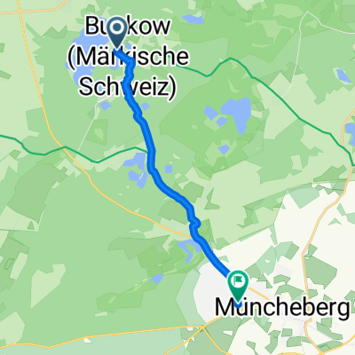
MOL CUP - Buckow - Straßenrennen
A cycling route starting in Buckow, Brandenburg, Germany.
Overview
About this route
Challenging race course:
Gradient of about 12 % right at the start!
About 1 KM of the route is within the town
cobblestones.
TT - Individual time trial:
-
1 lap of 13 KM (MOL CUP classification)
-
3-lap race of 13 KM = 39 KM
(Not in the MOL CUP classification)
- 6 laps of 13 KM = 78 KM
(MOL CUP classification)
- -:--
- Duration
- 13 km
- Distance
- 97 m
- Ascent
- 106 m
- Descent
- ---
- Avg. speed
- ---
- Max. altitude

Route highlights
Points of interest along the route
Point of interest after 0 km
Parkmöglichkeiten.
Point of interest after 0.2 km
Startunterlagen. Dusch- und Umkleidemöglichkeiten. Transponderausgabe im Start/Zielbereich.
Continue with Bikemap
Use, edit, or download this cycling route
You would like to ride MOL CUP - Buckow - Straßenrennen or customize it for your own trip? Here is what you can do with this Bikemap route:
Free features
- Save this route as favorite or in collections
- Copy & plan your own version of this route
- Sync your route with Garmin or Wahoo
Premium features
Free trial for 3 days, or one-time payment. More about Bikemap Premium.
- Navigate this route on iOS & Android
- Export a GPX / KML file of this route
- Create your custom printout (try it for free)
- Download this route for offline navigation
Discover more Premium features.
Get Bikemap PremiumFrom our community
Other popular routes starting in Buckow
 Teil 17: Von Buckow (Märkische Schweiz) bis Zützen
- Distance
- 109.2 km
- Ascent
- 226 m
- Descent
- 261 m
- Location
- Buckow, Brandenburg, Germany
 Am Markt nach Książęca
- Distance
- 66.3 km
- Ascent
- 173 m
- Descent
- 185 m
- Location
- Buckow, Brandenburg, Germany
 Buckow Rundtour
- Distance
- 37.3 km
- Ascent
- 218 m
- Descent
- 218 m
- Location
- Buckow, Brandenburg, Germany
 Märkische Tour
- Distance
- 27.4 km
- Ascent
- 125 m
- Descent
- 128 m
- Location
- Buckow, Brandenburg, Germany
 Crosserroute Buckow-Garzin-Buckow
- Distance
- 32.3 km
- Ascent
- 202 m
- Descent
- 202 m
- Location
- Buckow, Brandenburg, Germany
 Wriezener Straße nach Schwarzer Weg
- Distance
- 9.3 km
- Ascent
- 63 m
- Descent
- 71 m
- Location
- Buckow, Brandenburg, Germany
 Müncheberg - Oder - Bad Freienwalde 19.05.09
- Distance
- 98.4 km
- Ascent
- 162 m
- Descent
- 187 m
- Location
- Buckow, Brandenburg, Germany
 Buckow - Zechin
- Distance
- 38.2 km
- Ascent
- 193 m
- Descent
- 223 m
- Location
- Buckow, Brandenburg, Germany
Open it in the app