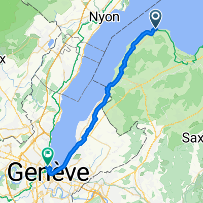
Nernier - Ballaison - Col de Saxel - Arbère Poche- Col du Feu- Port de Sechex - Nernier
A cycling route starting in Messery, Auvergne-RhĂ´ne-Alpes, France.
Overview
About this route
- -:--
- Duration
- 83.6 km
- Distance
- 1,532 m
- Ascent
- 1,537 m
- Descent
- ---
- Avg. speed
- 1,128 m
- Avg. speed
Route quality
Waytypes & surfaces along the route
Waytypes
Road
46.9 km
(56 %)
Busy road
15.1 km
(18 %)
Surfaces
Paved
65.7 km
(79 %)
Unpaved
1.9 km
(2 %)
Asphalt
65.7 km
(79 %)
Ground
1.4 km
(2 %)
Continue with Bikemap
Use, edit, or download this cycling route
You would like to ride Nernier - Ballaison - Col de Saxel - Arbère Poche- Col du Feu- Port de Sechex - Nernier or customize it for your own trip? Here is what you can do with this Bikemap route:
Free features
- Save this route as favorite or in collections
- Copy & plan your own version of this route
- Sync your route with Garmin or Wahoo
Premium features
Free trial for 3 days, or one-time payment. More about Bikemap Premium.
- Navigate this route on iOS & Android
- Export a GPX / KML file of this route
- Create your custom printout (try it for free)
- Download this route for offline navigation
Discover more Premium features.
Get Bikemap PremiumFrom our community
Other popular routes starting in Messery
- haute route alps juli 2015 ch/u
- Distance
- 728.6 km
- Ascent
- 13,408 m
- Descent
- 13,771 m
- Location
- Messery, Auvergne-RhĂ´ne-Alpes, France
- RGA Tag 1
- Distance
- 108.8 km
- Ascent
- 1,912 m
- Descent
- 1,305 m
- Location
- Messery, Auvergne-RhĂ´ne-Alpes, France
- Thonen to GVA
- Distance
- 27.4 km
- Ascent
- 155 m
- Descent
- 135 m
- Location
- Messery, Auvergne-RhĂ´ne-Alpes, France
- Yvoire to Taninges 82km 1740m climbing
- Distance
- 82.4 km
- Ascent
- 1,731 m
- Descent
- 1,467 m
- Location
- Messery, Auvergne-RhĂ´ne-Alpes, France
- Nernier - Ballaison - Col de Saxel - Arbère Poche- Col du Feu- Port de Sechex - Nernier
- Distance
- 83.6 km
- Ascent
- 1,532 m
- Descent
- 1,537 m
- Location
- Messery, Auvergne-RhĂ´ne-Alpes, France
- Ballaison-Moises-SĂŠchex
- Distance
- 63.6 km
- Ascent
- 1,144 m
- Descent
- 1,148 m
- Location
- Messery, Auvergne-RhĂ´ne-Alpes, France
- Elvetia-Franta 2010. Ziua 10
- Distance
- 20.9 km
- Ascent
- 131 m
- Descent
- 148 m
- Location
- Messery, Auvergne-RhĂ´ne-Alpes, France
- (05) Messery - Morzine
- Distance
- 92.6 km
- Ascent
- 1,461 m
- Descent
- 969 m
- Location
- Messery, Auvergne-RhĂ´ne-Alpes, France
Open it in the app