
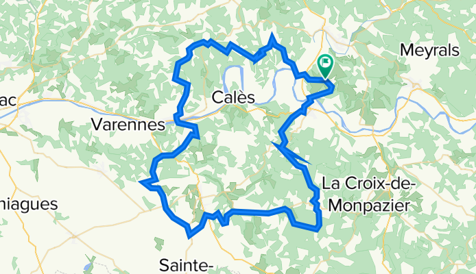
Fietsen langs de brug: Brug over La Vézere
A cycling route starting in Le Bugue, Nouvelle-Aquitaine, France.
Overview
About this route
This cycling loop takes you along some nice bike paths and trails by the bridge: Bridge over the Vézere. Nearly the entire route is slightly hilly. This route can be ridden in all seasons. The water of the Vézère (and also the landscape) always looks different.
- -:--
- Duration
- 97.6 km
- Distance
- 1,915 m
- Ascent
- 1,910 m
- Descent
- ---
- Avg. speed
- 238 m
- Max. altitude

Route quality
Waytypes & surfaces along the route
Waytypes
Quiet road
65.4 km
(67 %)
Road
23.4 km
(24 %)
Surfaces
Paved
43.9 km
(45 %)
Asphalt
43.9 km
(45 %)
Undefined
53.7 km
(55 %)
Continue with Bikemap
Use, edit, or download this cycling route
You would like to ride Fietsen langs de brug: Brug over La Vézere or customize it for your own trip? Here is what you can do with this Bikemap route:
Free features
- Save this route as favorite or in collections
- Copy & plan your own version of this route
- Split it into stages to create a multi-day tour
- Sync your route with Garmin or Wahoo
Premium features
Free trial for 3 days, or one-time payment. More about Bikemap Premium.
- Navigate this route on iOS & Android
- Export a GPX / KML file of this route
- Create your custom printout (try it for free)
- Download this route for offline navigation
Discover more Premium features.
Get Bikemap PremiumFrom our community
Other popular routes starting in Le Bugue
 Le Bugue-Audrix-Limeuil
- Distance
- 18.4 km
- Ascent
- 312 m
- Descent
- 312 m
- Location
- Le Bugue, Nouvelle-Aquitaine, France
 Limeuil Périgord
- Distance
- 49.4 km
- Ascent
- 510 m
- Descent
- 510 m
- Location
- Le Bugue, Nouvelle-Aquitaine, France
 4. Teilstück le buison de cadoin Payrac 98 km 1300
- Distance
- 97.9 km
- Ascent
- 767 m
- Descent
- 548 m
- Location
- Le Bugue, Nouvelle-Aquitaine, France
 Fietsen langs de brug: Brug over La Vézere
- Distance
- 97.6 km
- Ascent
- 1,915 m
- Descent
- 1,910 m
- Location
- Le Bugue, Nouvelle-Aquitaine, France
 France Stage 7
- Distance
- 95.9 km
- Ascent
- 996 m
- Descent
- 727 m
- Location
- Le Bugue, Nouvelle-Aquitaine, France
 Dag 2: Le Bugue-Jumilhac (do 11/7)
- Distance
- 85.5 km
- Ascent
- 706 m
- Descent
- 515 m
- Location
- Le Bugue, Nouvelle-Aquitaine, France
 France2023 E19
- Distance
- 59.9 km
- Ascent
- 612 m
- Descent
- 655 m
- Location
- Le Bugue, Nouvelle-Aquitaine, France
 Les Eyzier 2
- Distance
- 31.5 km
- Ascent
- 498 m
- Descent
- 498 m
- Location
- Le Bugue, Nouvelle-Aquitaine, France
Open it in the app