

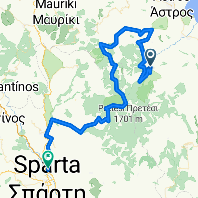
Agios Andreas to 11klms past kastanitsa at intersection
A cycling route starting in Ágios Andréas, Peloponnese, Greece.
Overview
About this route
Agios Andreas to well above kastanitsa village. to the highest possible asphalted road. this was a very good hill ride. going to kastanitsa had some hills for 2 klms min above 13% incline. and above kastanitsa it was constant and amongst walnut and chestnut trees and pine tree forest. lovely green and lush and heaps of fresh water springs to fill up the bottle. arcadian mountains rock!!!!!!!!!
- -:--
- Duration
- 31.8 km
- Distance
- 1,617 m
- Ascent
- 173 m
- Descent
- ---
- Avg. speed
- ---
- Avg. speed

Route quality
Waytypes & surfaces along the route
Waytypes
Road
25.2 km
(79 %)
Busy road
5.9 km
(18 %)
Surfaces
Paved
30.9 km
(97 %)
Asphalt
30.6 km
(96 %)
Concrete
0.4 km
(1 %)
Undefined
0.9 km
(3 %)
Continue with Bikemap
Use, edit, or download this cycling route
You would like to ride Agios Andreas to 11klms past kastanitsa at intersection or customize it for your own trip? Here is what you can do with this Bikemap route:
Free features
- Save this route as favorite or in collections
- Copy & plan your own version of this route
- Sync your route with Garmin or Wahoo
Premium features
Free trial for 3 days, or one-time payment. More about Bikemap Premium.
- Navigate this route on iOS & Android
- Export a GPX / KML file of this route
- Create your custom printout (try it for free)
- Download this route for offline navigation
Discover more Premium features.
Get Bikemap PremiumFrom our community
Other popular routes starting in Ágios Andréas
 8 Tappa Camping Zaritsi - Camping Atreus (Micene) 67 km
- Distance
- 67.3 km
- Ascent
- 485 m
- Descent
- 402 m
- Location
- Ágios Andréas, Peloponnese, Greece
 Arkadiko Chorio to Kosmas
- Distance
- 63.4 km
- Ascent
- 3,361 m
- Descent
- 2,205 m
- Location
- Ágios Andréas, Peloponnese, Greece
 Arkadiko to Kosmas
- Distance
- 63.4 km
- Ascent
- 3,362 m
- Descent
- 2,209 m
- Location
- Ágios Andréas, Peloponnese, Greece
 görgő9
- Distance
- 100.8 km
- Ascent
- 1,916 m
- Descent
- 2,107 m
- Location
- Ágios Andréas, Peloponnese, Greece
 Route to Notia Kynouria
- Distance
- 63.7 km
- Ascent
- 3,349 m
- Descent
- 2,479 m
- Location
- Ágios Andréas, Peloponnese, Greece
 Agios Andreas to 11klms past kastanitsa at intersection
- Distance
- 31.8 km
- Ascent
- 1,617 m
- Descent
- 173 m
- Location
- Ágios Andréas, Peloponnese, Greece
 Megali-Tourla-kör
- Distance
- 62.5 km
- Ascent
- 1,363 m
- Descent
- 1,361 m
- Location
- Ágios Andréas, Peloponnese, Greece
 Agios Andreas to Prasto (and back)
- Distance
- 23 km
- Ascent
- 840 m
- Descent
- 211 m
- Location
- Ágios Andréas, Peloponnese, Greece
Open it in the app