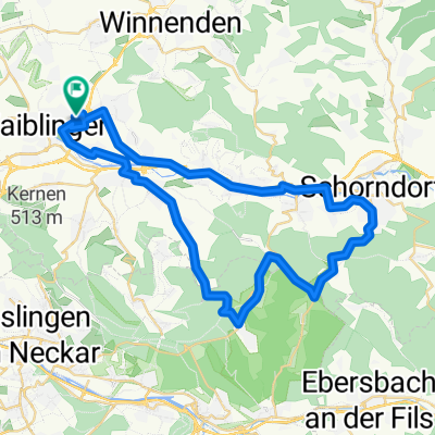
- 43.2 km
- 479 m
- 479 m
- Waiblingen, Baden-Wurttemberg, Germany
Kernen-Schorndorf-Kernen
A cycling route starting in Waiblingen, Baden-Wurttemberg, Germany.
Overview
About this route
A cozy cycling route. However, the return trip from Schorndorf to Kernen is very busy on weekends. For the inexperienced, the ascent to Korb might be a bit too steep. They can take the route from Beinstein to Großheppach. The track is mostly on bike paths or little-trafficked country roads.
- -:--
- Duration
- 39.3 km
- Distance
- 151 m
- Ascent
- 184 m
- Descent
- ---
- Avg. speed
- 302 m
- Max. altitude
created this 18 years ago
Route quality
Waytypes & surfaces along the route
Waytypes
Track
12.6 km
(32 %)
Quiet road
9.4 km
(24 %)
Surfaces
Paved
34.2 km
(87 %)
Unpaved
1.2 km
(3 %)
Asphalt
32.6 km
(83 %)
Paved (undefined)
1.6 km
(4 %)
Route highlights
Points of interest along the route
Point of interest after 39.1 km
Wiesenstraße
Continue with Bikemap
Use, edit, or download this cycling route
You would like to ride Kernen-Schorndorf-Kernen or customize it for your own trip? Here is what you can do with this Bikemap route:
Free features
- Save this route as favorite or in collections
- Copy & plan your own version of this route
- Sync your route with Garmin or Wahoo
Premium features
Free trial for 3 days, or one-time payment. More about Bikemap Premium.
- Navigate this route on iOS & Android
- Export a GPX / KML file of this route
- Create your custom printout (try it for free)
- Download this route for offline navigation
Discover more Premium features.
Get Bikemap PremiumFrom our community
Other popular routes starting in Waiblingen
- WN: Langer Kurs über Bittenfeld - Winnenden - Bouch
- Neckar / Rems Tour
- 41.6 km
- 242 m
- 242 m
- Waiblingen, Baden-Wurttemberg, Germany
- Waiblingen nach Althütte (Ebnisee) und zurück über Schorndorf nach Waiblingen
- 70.4 km
- 732 m
- 714 m
- Waiblingen, Baden-Wurttemberg, Germany
- E-Bike-Tour: Waiblingen - Ebnisee - Welzheim und über Schorndorf zurück
- 88.9 km
- 1,366 m
- 1,366 m
- Waiblingen, Baden-Wurttemberg, Germany
- Rems und Neckar
- 52.1 km
- 181 m
- 196 m
- Waiblingen, Baden-Wurttemberg, Germany
- Durch den Buocher Wald
- 48.9 km
- 492 m
- 492 m
- Waiblingen, Baden-Wurttemberg, Germany
- 56,5km Waiblingen Asperg
- 56.5 km
- 641 m
- 640 m
- Waiblingen, Baden-Wurttemberg, Germany
- Runde um den Schurwald
- 41.4 km
- 489 m
- 534 m
- Waiblingen, Baden-Wurttemberg, Germany
Open it in the app


