

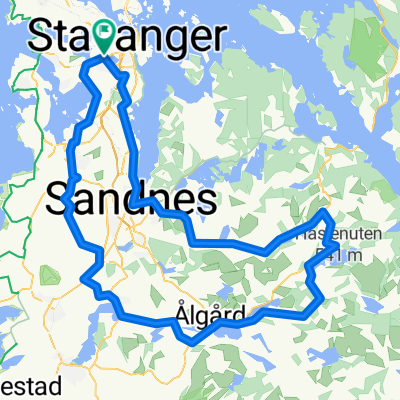
StaRaSoSa_lang rute
A cycling route starting in Stavanger, Rogaland, Norway.
Overview
About this route
- -:--
- Duration
- 73.5 km
- Distance
- 251 m
- Ascent
- 251 m
- Descent
- ---
- Avg. speed
- ---
- Max. altitude
Route quality
Waytypes & surfaces along the route
Waytypes
Cycleway
20.6 km
(28 %)
Pedestrian area
19.1 km
(26 %)
Surfaces
Paved
33.1 km
(45 %)
Unpaved
16.2 km
(22 %)
Asphalt
30.1 km
(41 %)
Unpaved (undefined)
7.3 km
(10 %)
Route highlights
Points of interest along the route
Point of interest after 20.5 km
20Km
Point of interest after 29.5 km
30Km
Point of interest after 39.3 km
40Km
Point of interest after 50.5 km
50Km
Point of interest after 69.3 km
70Km
Point of interest after 73.5 km
Point of interest after 73.5 km
Continue with Bikemap
Use, edit, or download this cycling route
You would like to ride StaRaSoSa_lang rute or customize it for your own trip? Here is what you can do with this Bikemap route:
Free features
- Save this route as favorite or in collections
- Copy & plan your own version of this route
- Sync your route with Garmin or Wahoo
Premium features
Free trial for 3 days, or one-time payment. More about Bikemap Premium.
- Navigate this route on iOS & Android
- Export a GPX / KML file of this route
- Create your custom printout (try it for free)
- Download this route for offline navigation
Discover more Premium features.
Get Bikemap PremiumFrom our community
Other popular routes starting in Stavanger
 27.april
- Distance
- 93.6 km
- Ascent
- 960 m
- Descent
- 983 m
- Location
- Stavanger, Rogaland, Norway
 Norway 2: Stavanger-Tau-Preikestolen-Tau-Stavanger
- Distance
- 91.9 km
- Ascent
- 750 m
- Descent
- 750 m
- Location
- Stavanger, Rogaland, Norway
 Steady ride from Kleivane to Troll skogen
- Distance
- 24.7 km
- Ascent
- 215 m
- Descent
- 155 m
- Location
- Stavanger, Rogaland, Norway
 Stavanger-Kristiansand
- Distance
- 380.9 km
- Ascent
- 6,255 m
- Descent
- 6,277 m
- Location
- Stavanger, Rogaland, Norway
 Stavanger - Mandal
- Distance
- 261.8 km
- Ascent
- 1,575 m
- Descent
- 1,644 m
- Location
- Stavanger, Rogaland, Norway
 Lauritz Bergendahls gate 29, Stavanger to Thorleif Haugs gate 30, Stavanger
- Distance
- 12.6 km
- Ascent
- 137 m
- Descent
- 137 m
- Location
- Stavanger, Rogaland, Norway
 StaRaSoSa_lang rute
- Distance
- 73.5 km
- Ascent
- 251 m
- Descent
- 251 m
- Location
- Stavanger, Rogaland, Norway
 stavanger - Borestrand of Obrestad fyrstasjon
- Distance
- 57.4 km
- Ascent
- 222 m
- Descent
- 250 m
- Location
- Stavanger, Rogaland, Norway
Open it in the app