

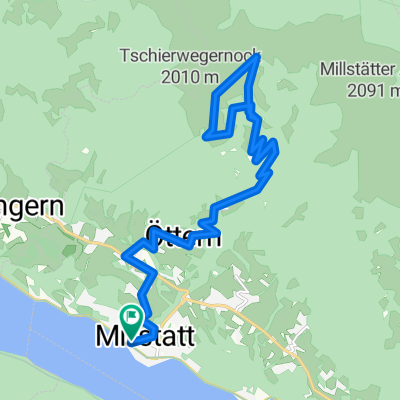
KäS2: Millstätt-Weissensee; 55,2km 730hm
A cycling route starting in Millstatt, Carinthia, Austria.
Overview
About this route
Millstätt - (R2B) - Seeboden - Seebach - (R9) - Karlsdorf - (R9A) - Lendorf - (EV7/R1) - Sachsenburg - Steinfeld - Pobersach - (Wunderbaumrunde) - Schattseit - Techendorf - Gatschach - Oberdorf
Kraners Alpenhof, Oberdorf 13, 9762 Oberdorf, Austria
- -:--
- Duration
- 55.2 km
- Distance
- 912 m
- Ascent
- 608 m
- Descent
- ---
- Avg. speed
- 975 m
- Max. altitude

Route quality
Waytypes & surfaces along the route
Waytypes
Quiet road
18.2 km
(33 %)
Track
8.8 km
(16 %)
Surfaces
Paved
37.6 km
(68 %)
Unpaved
7.7 km
(14 %)
Asphalt
35.9 km
(65 %)
Gravel
5.5 km
(10 %)
Route highlights
Points of interest along the route
Point of interest after 2.3 km
Super Badestelle
Point of interest after 4.4 km
Badestelle mit Wiese

Point of interest after 5.1 km
Blumenpark

Point of interest after 6.1 km
Nixe vom Millstätter See
Point of interest after 26.9 km
Rastplatz
Point of interest after 27.8 km
Rastplatz
Point of interest after 28.3 km
Genußhütte
Point of interest after 41.8 km
Jausenstation

Point of interest after 53.5 km
Aussichtsturm und Aussichtspunkt
Point of interest after 54.5 km
Strandbad

Accommodation after 55.2 km
Kraners Alpenhof Oberdorf 13 9762 Oberdorf
Continue with Bikemap
Use, edit, or download this cycling route
You would like to ride KäS2: Millstätt-Weissensee; 55,2km 730hm or customize it for your own trip? Here is what you can do with this Bikemap route:
Free features
- Save this route as favorite or in collections
- Copy & plan your own version of this route
- Sync your route with Garmin or Wahoo
Premium features
Free trial for 3 days, or one-time payment. More about Bikemap Premium.
- Navigate this route on iOS & Android
- Export a GPX / KML file of this route
- Create your custom printout (try it for free)
- Download this route for offline navigation
Discover more Premium features.
Get Bikemap PremiumFrom our community
Other popular routes starting in Millstatt
 KäS2: Millstätt-Weissensee; 55,2km 730hm
- Distance
- 55.2 km
- Ascent
- 912 m
- Descent
- 608 m
- Location
- Millstatt, Carinthia, Austria
 Nockalmstrasse
- Distance
- 106 km
- Ascent
- 2,183 m
- Descent
- 2,185 m
- Location
- Millstatt, Carinthia, Austria
 Radrunde vom 21. Juli, 06:49
- Distance
- 29.7 km
- Ascent
- 1,279 m
- Descent
- 1,409 m
- Location
- Millstatt, Carinthia, Austria
 Dráva túra 2. nap
- Distance
- 133 km
- Ascent
- 523 m
- Descent
- 729 m
- Location
- Millstatt, Carinthia, Austria
 Lechnerschaft 661/1 nach Lechnerschaft 661/1
- Distance
- 29.3 km
- Ascent
- 408 m
- Descent
- 406 m
- Location
- Millstatt, Carinthia, Austria
 Matzelsdorf-Laufenberg
- Distance
- 33 km
- Ascent
- 1,431 m
- Descent
- 1,423 m
- Location
- Millstatt, Carinthia, Austria
 Drei Hütten Tour
- Distance
- 26.5 km
- Ascent
- 1,258 m
- Descent
- 1,258 m
- Location
- Millstatt, Carinthia, Austria
 Über die Millstätter Alpe
- Distance
- 44.9 km
- Ascent
- 1,701 m
- Descent
- 1,711 m
- Location
- Millstatt, Carinthia, Austria
Open it in the app