

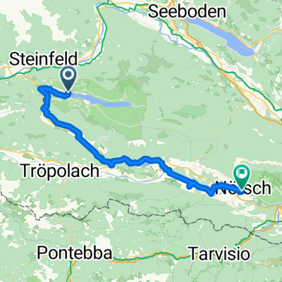
KäS3: Weissensee-Gödersdorf; 71,3km 360hm
A cycling route starting in Steinfeld, Carinthia, Austria.
Overview
About this route
Weissensee - Weißbriach - (R3B) - St.Lorenzen - Jadersdorf - Obermöschbach - Hermagor - (R3A) - Eggforst - Untervellach - Pressegger See - Görtschach - (R3) - St.Stefan - Emmersdorf - Nötsch - Arnoldstein - Unterfederaun - Gödersdorf
Is the Gailtal bike route R3 Nötsch-Suha-Arnoldstein closed?
Hotel Restaurant Zollner, Finkensteiner Str. 14, 9585 Gödersdorf near Villach, Austria
- -:--
- Duration
- 74.4 km
- Distance
- 554 m
- Ascent
- 952 m
- Descent
- ---
- Avg. speed
- 1,085 m
- Max. altitude

Route quality
Waytypes & surfaces along the route
Waytypes
Cycleway
19.4 km
(26 %)
Quiet road
17.9 km
(24 %)
Surfaces
Paved
41.7 km
(56 %)
Unpaved
12.7 km
(17 %)
Asphalt
40.9 km
(55 %)
Loose gravel
6 km
(8 %)
Route highlights
Points of interest along the route
Point of interest after 25.6 km
Pressegger See
Point of interest after 27.2 km
Badeanstalt
Point of interest after 45.6 km
Ist der R3 nach Arnoldstein gesperrt?
Point of interest after 47.2 km
Rastplatz
Point of interest after 72.5 km
Rastbank

Accommodation after 74.4 km
Hotel Restaurant Zollner Finkensteiner Str. 14 9585 Gödersdorf bei Villach
Continue with Bikemap
Use, edit, or download this cycling route
You would like to ride KäS3: Weissensee-Gödersdorf; 71,3km 360hm or customize it for your own trip? Here is what you can do with this Bikemap route:
Free features
- Save this route as favorite or in collections
- Copy & plan your own version of this route
- Sync your route with Garmin or Wahoo
Premium features
Free trial for 3 days, or one-time payment. More about Bikemap Premium.
- Navigate this route on iOS & Android
- Export a GPX / KML file of this route
- Create your custom printout (try it for free)
- Download this route for offline navigation
Discover more Premium features.
Get Bikemap PremiumFrom our community
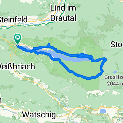
Other popular routes starting in Steinfeld
 Short ride from Weißensee to Techendorf
- Distance
- 5.8 km
- Ascent
- 197 m
- Descent
- 580 m
- Location
- Steinfeld, Carinthia, Austria
 Techendorf 96, Weissensee a Urbeleweg, Stockenboi
- Distance
- 32 km
- Ascent
- 660 m
- Descent
- 644 m
- Location
- Steinfeld, Carinthia, Austria
 von Kleblach-Lind nach Unterkolbnitz
- Distance
- 44 km
- Ascent
- 549 m
- Descent
- 549 m
- Location
- Steinfeld, Carinthia, Austria
 Techendorf über Kreuzbergsattel nach Weißbriach, Hermagor bis Nötsch
- Distance
- 50.5 km
- Ascent
- 535 m
- Descent
- 909 m
- Location
- Steinfeld, Carinthia, Austria
 R3 ab Hotel 25km 360HM Boot zurück
- Distance
- 25.8 km
- Ascent
- 422 m
- Descent
- 428 m
- Location
- Steinfeld, Carinthia, Austria
 Weißensee Kohlrösselhütte Kreuzberg Hermagor
- Distance
- 46.7 km
- Ascent
- 1,084 m
- Descent
- 1,509 m
- Location
- Steinfeld, Carinthia, Austria
 grosse Weissensee Runde
- Distance
- 44.5 km
- Ascent
- 1,048 m
- Descent
- 1,099 m
- Location
- Steinfeld, Carinthia, Austria
 KäS3: Weissensee-Gödersdorf; 71,3km 360hm
- Distance
- 74.4 km
- Ascent
- 554 m
- Descent
- 952 m
- Location
- Steinfeld, Carinthia, Austria
Open it in the app