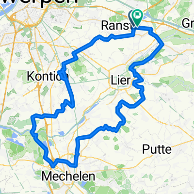
in het park van Wijnegem
A cycling route starting in Ranst, Flemish Region, Belgium.
Overview
About this route
Van Torekenshoefstraat 8, 2520 Emblem, België Naar Torekenshoefstraat 8, 2520 Emblem, België Routering Racefiets - mooiste
- -:--
- Duration
- 51.1 km
- Distance
- 84 m
- Ascent
- 84 m
- Descent
- ---
- Avg. speed
- 21 m
- Avg. speed
Route quality
Waytypes & surfaces along the route
Waytypes
Quiet road
27.9 km
(55 %)
Cycleway
14.9 km
(29 %)
Surfaces
Paved
32.2 km
(63 %)
Asphalt
21.2 km
(42 %)
Concrete
5.6 km
(11 %)
Continue with Bikemap
Use, edit, or download this cycling route
You would like to ride in het park van Wijnegem or customize it for your own trip? Here is what you can do with this Bikemap route:
Free features
- Save this route as favorite or in collections
- Copy & plan your own version of this route
- Sync your route with Garmin or Wahoo
Premium features
Free trial for 3 days, or one-time payment. More about Bikemap Premium.
- Navigate this route on iOS & Android
- Export a GPX / KML file of this route
- Create your custom printout (try it for free)
- Download this route for offline navigation
Discover more Premium features.
Get Bikemap PremiumFrom our community
Other popular routes starting in Ranst
- kempen 70km
- Distance
- 71.7 km
- Ascent
- 108 m
- Descent
- 106 m
- Location
- Ranst, Flemish Region, Belgium
- tielen,
- Distance
- 73.2 km
- Ascent
- 68 m
- Descent
- 67 m
- Location
- Ranst, Flemish Region, Belgium
- Vremde
- Distance
- 37.3 km
- Ascent
- 28 m
- Descent
- 25 m
- Location
- Ranst, Flemish Region, Belgium
- Emblem
- Distance
- 51.8 km
- Ascent
- 52 m
- Descent
- 52 m
- Location
- Ranst, Flemish Region, Belgium
- Rondje Kempen
- Distance
- 56.9 km
- Ascent
- 96 m
- Descent
- 94 m
- Location
- Ranst, Flemish Region, Belgium
- Boechout, Lier, Grobbendonk
- Distance
- 49.1 km
- Ascent
- 49 m
- Descent
- 49 m
- Location
- Ranst, Flemish Region, Belgium
- in het park van Wijnegem
- Distance
- 51.1 km
- Ascent
- 84 m
- Descent
- 84 m
- Location
- Ranst, Flemish Region, Belgium
- Havenroute: stabroek-Putte-Maria ter heide-Brasschaat-Schoten
- Distance
- 69.8 km
- Ascent
- 32 m
- Descent
- 35 m
- Location
- Ranst, Flemish Region, Belgium
Open it in the app