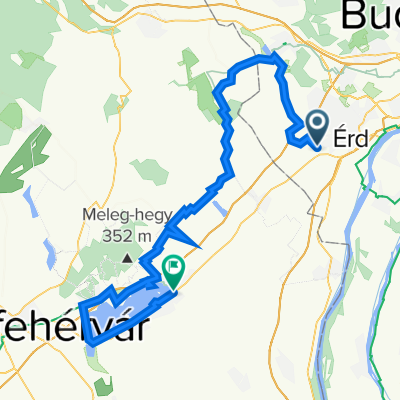
agoston
A cycling route starting in Tárnok, Pest megye, Hungary.
Overview
About this route
- -:--
- Duration
- 85.6 km
- Distance
- 593 m
- Ascent
- 596 m
- Descent
- ---
- Avg. speed
- 257 m
- Avg. speed
Route quality
Waytypes & surfaces along the route
Waytypes
Quiet road
35.3 km
(41 %)
Busy road
20.8 km
(24 %)
Surfaces
Paved
67.1 km
(78 %)
Unpaved
0.1 km
(<1 %)
Asphalt
59.1 km
(69 %)
Paving stones
5 km
(6 %)
Continue with Bikemap
Use, edit, or download this cycling route
You would like to ride agoston or customize it for your own trip? Here is what you can do with this Bikemap route:
Free features
- Save this route as favorite or in collections
- Copy & plan your own version of this route
- Sync your route with Garmin or Wahoo
Premium features
Free trial for 3 days, or one-time payment. More about Bikemap Premium.
- Navigate this route on iOS & Android
- Export a GPX / KML file of this route
- Create your custom printout (try it for free)
- Download this route for offline navigation
Discover more Premium features.
Get Bikemap PremiumFrom our community
Other popular routes starting in Tárnok
- Sóskút Pusztazámor karika
- Distance
- 13 km
- Ascent
- 118 m
- Descent
- 116 m
- Location
- Tárnok, Pest megye, Hungary
- Szabadság utca 75, Tárnok to Dózsa György út 106, Tárnok
- Distance
- 27 km
- Ascent
- 199 m
- Descent
- 201 m
- Location
- Tárnok, Pest megye, Hungary
- Hazatérők útja 4, Tárnok to Diósdi utca 236157, Budapest
- Distance
- 13.2 km
- Ascent
- 50 m
- Descent
- 48 m
- Location
- Tárnok, Pest megye, Hungary
- agoston
- Distance
- 85.6 km
- Ascent
- 593 m
- Descent
- 596 m
- Location
- Tárnok, Pest megye, Hungary
- Tárnok-Etyek-Alcsútdoboz-Baracska
- Distance
- 57.1 km
- Ascent
- 296 m
- Descent
- 292 m
- Location
- Tárnok, Pest megye, Hungary
- Csepel 2
- Distance
- 23.4 km
- Ascent
- 243 m
- Descent
- 238 m
- Location
- Tárnok, Pest megye, Hungary
- agostonnal2222
- Distance
- 100.2 km
- Ascent
- 767 m
- Descent
- 765 m
- Location
- Tárnok, Pest megye, Hungary
- Tárnok-Biatorbágy-Etyek-Alcsútdoboz-Felcsút-Szár
- Distance
- 48.8 km
- Ascent
- 348 m
- Descent
- 259 m
- Location
- Tárnok, Pest megye, Hungary
Open it in the app