
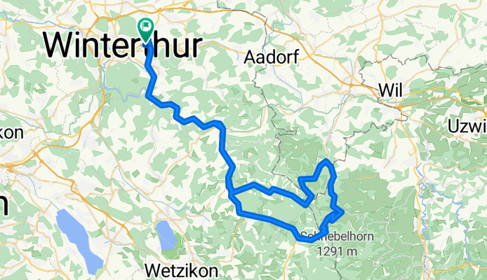
Winterthur-Hulftegg-Sternenberg-Winterthur
A cycling route starting in Oberwinterthur (Kreis 2) / Talacker, Canton of Zurich, Switzerland.
Overview
About this route
Winterthur-Hulftegg-Sternenberg-Winterthur
- -:--
- Duration
- 80.1 km
- Distance
- 804 m
- Ascent
- 803 m
- Descent
- ---
- Avg. speed
- ---
- Max. altitude
Route quality
Waytypes & surfaces along the route
Waytypes
Busy road
36.5 km
(46 %)
Road
20.9 km
(26 %)
Surfaces
Paved
64.2 km
(80 %)
Unpaved
2.7 km
(3 %)
Asphalt
64 km
(80 %)
Gravel
2.1 km
(3 %)
Continue with Bikemap
Use, edit, or download this cycling route
You would like to ride Winterthur-Hulftegg-Sternenberg-Winterthur or customize it for your own trip? Here is what you can do with this Bikemap route:
Free features
- Save this route as favorite or in collections
- Copy & plan your own version of this route
- Split it into stages to create a multi-day tour
- Sync your route with Garmin or Wahoo
Premium features
Free trial for 3 days, or one-time payment. More about Bikemap Premium.
- Navigate this route on iOS & Android
- Export a GPX / KML file of this route
- Create your custom printout (try it for free)
- Download this route for offline navigation
Discover more Premium features.
Get Bikemap PremiumFrom our community
Other popular routes starting in Oberwinterthur (Kreis 2) / Talacker
 Oberi-Etzberg-Iberg-Eschenberg-Oberi
- Distance
- 19.7 km
- Ascent
- 353 m
- Descent
- 344 m
- Location
- Oberwinterthur (Kreis 2) / Talacker, Canton of Zurich, Switzerland
 Winterthur - Zürich - Uster - Sternenberg - Elgg - Winterthur
- Distance
- 99.8 km
- Ascent
- 856 m
- Descent
- 858 m
- Location
- Oberwinterthur (Kreis 2) / Talacker, Canton of Zurich, Switzerland
 Winterthur - Zürich direkt
- Distance
- 26 km
- Ascent
- 178 m
- Descent
- 233 m
- Location
- Oberwinterthur (Kreis 2) / Talacker, Canton of Zurich, Switzerland
 Winterthur - Klausen - Furka -Zermatt - Chamonix - Geneve
- Distance
- 556.9 km
- Ascent
- 5,574 m
- Descent
- 5,653 m
- Location
- Oberwinterthur (Kreis 2) / Talacker, Canton of Zurich, Switzerland
 Turbenthal-Girenbad-Runde
- Distance
- 48 km
- Ascent
- 463 m
- Descent
- 459 m
- Location
- Oberwinterthur (Kreis 2) / Talacker, Canton of Zurich, Switzerland
 Dussnang-Sitzberg-Wildberg-Girenbad
- Distance
- 66.8 km
- Ascent
- 930 m
- Descent
- 930 m
- Location
- Oberwinterthur (Kreis 2) / Talacker, Canton of Zurich, Switzerland
 Winterthur - Hulftegg klein
- Distance
- 67.5 km
- Ascent
- 612 m
- Descent
- 605 m
- Location
- Oberwinterthur (Kreis 2) / Talacker, Canton of Zurich, Switzerland
 Winti - Wila an Töss entlang
- Distance
- 34.2 km
- Ascent
- 225 m
- Descent
- 230 m
- Location
- Oberwinterthur (Kreis 2) / Talacker, Canton of Zurich, Switzerland
Open it in the app