
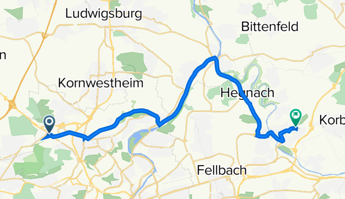
Schwieberdinger Straße 147, Stuttgart nach Stauferstraße 19, Waiblingen
A cycling route starting in Korntal, Baden-Württemberg, Germany.
Overview
About this route
- 54 min
- Duration
- 20.7 km
- Distance
- 188 m
- Ascent
- 212 m
- Descent
- 22.9 km/h
- Avg. speed
- 313 m
- Max. altitude

Route quality
Waytypes & surfaces along the route
Waytypes
Quiet road
4.8 km
(23 %)
Busy road
4.3 km
(21 %)
Surfaces
Paved
20.1 km
(97 %)
Unpaved
0.5 km
(2 %)
Asphalt
19.7 km
(95 %)
Gravel
0.4 km
(2 %)
Continue with Bikemap
Use, edit, or download this cycling route
You would like to ride Schwieberdinger Straße 147, Stuttgart nach Stauferstraße 19, Waiblingen or customize it for your own trip? Here is what you can do with this Bikemap route:
Free features
- Save this route as favorite or in collections
- Copy & plan your own version of this route
- Sync your route with Garmin or Wahoo
Premium features
Free trial for 3 days, or one-time payment. More about Bikemap Premium.
- Navigate this route on iOS & Android
- Export a GPX / KML file of this route
- Create your custom printout (try it for free)
- Download this route for offline navigation
Discover more Premium features.
Get Bikemap PremiumFrom our community
Other popular routes starting in Korntal
 Neuhaldenstraße, Korntal-Münchingen nach Mahdentalstraße, Stuttgart
- Distance
- 10.5 km
- Ascent
- 228 m
- Descent
- 117 m
- Location
- Korntal, Baden-Württemberg, Germany
 Haus nach Hemmingen
- Distance
- 56.9 km
- Ascent
- 643 m
- Descent
- 645 m
- Location
- Korntal, Baden-Württemberg, Germany
 Standardrunde
- Distance
- 61.6 km
- Ascent
- 818 m
- Descent
- 739 m
- Location
- Korntal, Baden-Württemberg, Germany
 RTF Gäutour 2009 Tour B
- Distance
- 125.2 km
- Ascent
- 1,147 m
- Descent
- 1,170 m
- Location
- Korntal, Baden-Württemberg, Germany
 Kleine Standardrunde
- Distance
- 20.8 km
- Ascent
- 141 m
- Descent
- 141 m
- Location
- Korntal, Baden-Württemberg, Germany
 Zuffenhausen-Bad Urach
- Distance
- 80.4 km
- Ascent
- 617 m
- Descent
- 453 m
- Location
- Korntal, Baden-Württemberg, Germany
 Korntal-Birkenkopf-Schillerhöhe-Glems
- Distance
- 34.1 km
- Ascent
- 381 m
- Descent
- 381 m
- Location
- Korntal, Baden-Württemberg, Germany
 Gerlingen - Wasserturm Böblingen und zurück
- Distance
- 47.7 km
- Ascent
- 756 m
- Descent
- 756 m
- Location
- Korntal, Baden-Württemberg, Germany
Open it in the app