
Hoogtemeters maken in de Ardennen
A cycling route starting in Büllingen, Wallonia, Belgium.
Overview
About this route
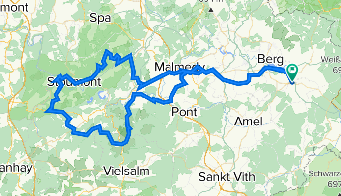
The route starts in Spa. First, there is a climb to the village of Creppe. After Creppe, the roads become quieter and descend to Winamplanche. Then follows the ascent of Côté Desnie. After the long descent of 6 km, you leave the valley of the Amblève and climb the beautiful Côté de Chession. Via Chevron, you descend into the very quiet valley of the Lienne (where luckily the road was repaved a few years ago). Note: the descent is very steep (up to 20%). Then you go northwards following the Lienne downstream. Next comes the beautiful Côté de Xhierfomont with 4 hairpin bends. After that, the climb of La Levée follows. Then it’s a mix of ups and downs on good roads with beautiful views, and you climb the second part of Côté de Saint-Jacques. Then follows the long descent to the foot of the challenging Côté de Wanne. The descent of Côté de Wanne (this is known in the climbing direction as Côté de Wanneranval) towards Stavelot is beautiful and steep (up to 15%). Then it slightly ascends to Beaumont (although the first half kilometer is still at 8 - 9%) and then follows the climb of Côté de Ronxhi. After the descent, you ride 8 kilometers along the paved bike path along the former railway line. Upon arriving in Stavelot, you climb the Côté d'Amermont. After the descent of Côté de Neuville, there remains the beautiful Côté du Rosier-Est and the descent to Spa.
- -:--
- Duration
- 120.4 km
- Distance
- 2,359 m
- Ascent
- 2,361 m
- Descent
- ---
- Avg. speed
- 589 m
- Max. altitude

Route quality
Waytypes & surfaces along the route
Waytypes
Road
50.5 km
(42 %)
Cycleway
33.7 km
(28 %)
Surfaces
Paved
78.2 km
(65 %)
Unpaved
1.2 km
(1 %)
Asphalt
78.2 km
(65 %)
Ground
1.2 km
(1 %)
Undefined
40.9 km
(34 %)
Continue with Bikemap
Use, edit, or download this cycling route
You would like to ride Hoogtemeters maken in de Ardennen or customize it for your own trip? Here is what you can do with this Bikemap route:
Free features
- Save this route as favorite or in collections
- Copy & plan your own version of this route
- Split it into stages to create a multi-day tour
- Sync your route with Garmin or Wahoo
Premium features
Free trial for 3 days, or one-time payment. More about Bikemap Premium.
- Navigate this route on iOS & Android
- Export a GPX / KML file of this route
- Create your custom printout (try it for free)
- Download this route for offline navigation
Discover more Premium features.
Get Bikemap PremiumFrom our community
Other popular routes starting in Büllingen
 rund um den see
- Distance
- 21.5 km
- Ascent
- 182 m
- Descent
- 184 m
- Location
- Büllingen, Wallonia, Belgium
 Runde um Elsenborn
- Distance
- 40.3 km
- Ascent
- 366 m
- Descent
- 367 m
- Location
- Büllingen, Wallonia, Belgium
 Büllingen - Blankenheim
- Distance
- 31.6 km
- Ascent
- 224 m
- Descent
- 317 m
- Location
- Büllingen, Wallonia, Belgium
 Site2Site Run 5: Medendorf > Clermont
- Distance
- 61.9 km
- Ascent
- 515 m
- Descent
- 763 m
- Location
- Büllingen, Wallonia, Belgium
 Hoogtemeters maken in de Ardennen
- Distance
- 120.4 km
- Ascent
- 2,359 m
- Descent
- 2,361 m
- Location
- Büllingen, Wallonia, Belgium
 wirtzfeld- vielsalm-trois pont - wirtzfeld
- Distance
- 91.1 km
- Ascent
- 473 m
- Descent
- 465 m
- Location
- Büllingen, Wallonia, Belgium
 Meet Voorjaarsweekend 2016 Team Terras dag 1
- Distance
- 46.3 km
- Ascent
- 425 m
- Descent
- 425 m
- Location
- Büllingen, Wallonia, Belgium
 Meet Voorjaarsweekend 2016 Team Kleppers dag 3
- Distance
- 157.7 km
- Ascent
- 1,833 m
- Descent
- 1,833 m
- Location
- Büllingen, Wallonia, Belgium
Open it in the app