

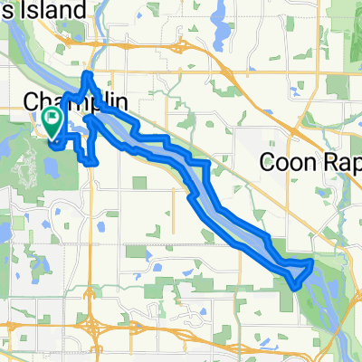
Elm Creek_Coon Rapids Dam Loop via Anoka & e. shore Mississippi
A cycling route starting in Champlin, Minnesota, United States.
Overview
About this route
Elm Creek_Coon Rapids Dam Loop via Anoka & e. shore Mississippi
- -:--
- Duration
- 45.8 km
- Distance
- 125 m
- Ascent
- 115 m
- Descent
- ---
- Avg. speed
- 278 m
- Max. altitude
Route quality
Waytypes & surfaces along the route
Waytypes
Road
20.4 km
(44 %)
Cycleway
15.2 km
(33 %)
Surfaces
Paved
43.1 km
(94 %)
Asphalt
40.2 km
(88 %)
Concrete
2.9 km
(6 %)
Continue with Bikemap
Use, edit, or download this cycling route
You would like to ride Elm Creek_Coon Rapids Dam Loop via Anoka & e. shore Mississippi or customize it for your own trip? Here is what you can do with this Bikemap route:
Free features
- Save this route as favorite or in collections
- Copy & plan your own version of this route
- Sync your route with Garmin or Wahoo
Premium features
Free trial for 3 days, or one-time payment. More about Bikemap Premium.
- Navigate this route on iOS & Android
- Export a GPX / KML file of this route
- Create your custom printout (try it for free)
- Download this route for offline navigation
Discover more Premium features.
Get Bikemap PremiumFrom our community
Other popular routes starting in Champlin
 Elm Creek_Coon Rapids Dam Loop via Anoka & e. shore Mississippi
- Distance
- 45.8 km
- Ascent
- 125 m
- Descent
- 115 m
- Location
- Champlin, Minnesota, United States
 Great Circle Route - Lake Minnetonka
- Distance
- 115.7 km
- Ascent
- 187 m
- Descent
- 188 m
- Location
- Champlin, Minnesota, United States
 Champlin to home
- Distance
- 41 km
- Ascent
- 120 m
- Descent
- 141 m
- Location
- Champlin, Minnesota, United States
 Near Elm Creek Park Reserve to North Hennepin Community College
- Distance
- 12.3 km
- Ascent
- 14 m
- Descent
- 22 m
- Location
- Champlin, Minnesota, United States
 Elm Creek Park Reserve to Medtronic MV Campus
- Distance
- 25.2 km
- Ascent
- 45 m
- Descent
- 46 m
- Location
- Champlin, Minnesota, United States
 anoka dam
- Distance
- 27.3 km
- Ascent
- 59 m
- Descent
- 59 m
- Location
- Champlin, Minnesota, United States
 Elm Creek Intermediate and Advanced loop
- Distance
- 19 km
- Ascent
- 68 m
- Descent
- 87 m
- Location
- Champlin, Minnesota, United States
 Long way to New Hope
- Distance
- 68.7 km
- Ascent
- 645 m
- Descent
- 698 m
- Location
- Champlin, Minnesota, United States
Open it in the app