

Ventnor Blast
A cycling route starting in Ventnor, England, United Kingdom.
Overview
About this route
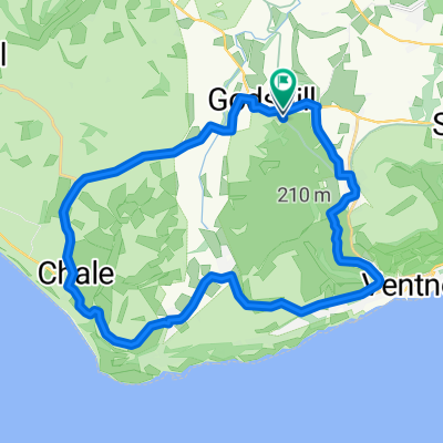
Early morning speed trial! This is an amazing, short 12.4k route with super fast desent to Ventnor Esplanade, flat section to enjoy the beach & sea views followed by a steep climb, back up to Rew Lane before returning to the start at the centre of Wroxall. This route is all metal road surface and concrete so suitable for a wide range of bikes. You really don't have to race it tho! However, I recommend early morning as you can enjoy the 'fast', twisty section (and sunrise!) from Upper Ventnor to Bonchurch. It's best not to meet a bus on route! Otherwise, a full moon would be good fun to ride? Enjoy :) p.s - yes, of course you can start the route at any point. I'd be interested to hear your time too!
- -:--
- Duration
- 12.4 km
- Distance
- 225 m
- Ascent
- 229 m
- Descent
- ---
- Avg. speed
- 136 m
- Avg. speed

Route quality
Waytypes & surfaces along the route
Waytypes
Busy road
6.2 km
(50 %)
Quiet road
3.7 km
(30 %)
Surfaces
Paved
10.6 km
(85 %)
Asphalt
10.5 km
(84 %)
Concrete
0.1 km
(1 %)
Undefined
1.8 km
(15 %)
Continue with Bikemap
Use, edit, or download this cycling route
You would like to ride Ventnor Blast or customize it for your own trip? Here is what you can do with this Bikemap route:
Free features
- Save this route as favorite or in collections
- Copy & plan your own version of this route
- Sync your route with Garmin or Wahoo
Premium features
Free trial for 3 days, or one-time payment. More about Bikemap Premium.
- Navigate this route on iOS & Android
- Export a GPX / KML file of this route
- Create your custom printout (try it for free)
- Download this route for offline navigation
Discover more Premium features.
Get Bikemap PremiumFrom our community
Other popular routes starting in Ventnor
 Chalk Ridge Extreme Route
- Distance
- 93.2 km
- Ascent
- 1,115 m
- Descent
- 1,114 m
- Location
- Ventnor, England, United Kingdom
 IOW 17 mile
- Distance
- 25.6 km
- Ascent
- 252 m
- Descent
- 263 m
- Location
- Ventnor, England, United Kingdom
 Ravens Route 21.2 miles.
- Distance
- 48.6 km
- Ascent
- 420 m
- Descent
- 428 m
- Location
- Ventnor, England, United Kingdom
 Isle of Wight 109km
- Distance
- 109 km
- Ascent
- 608 m
- Descent
- 608 m
- Location
- Ventnor, England, United Kingdom
 St. Lawrence & Undercliffe Drive.
- Distance
- 23.4 km
- Ascent
- 335 m
- Descent
- 337 m
- Location
- Ventnor, England, United Kingdom
 Chillerton Tour - Via Whitwell & Roud
- Distance
- 35.4 km
- Ascent
- 347 m
- Descent
- 348 m
- Location
- Ventnor, England, United Kingdom
 Wroxall Rookley Wroxall
- Distance
- 22.4 km
- Ascent
- 207 m
- Descent
- 195 m
- Location
- Ventnor, England, United Kingdom
 Little Loop
- Distance
- 20.2 km
- Ascent
- 135 m
- Descent
- 136 m
- Location
- Ventnor, England, United Kingdom
Open it in the app