

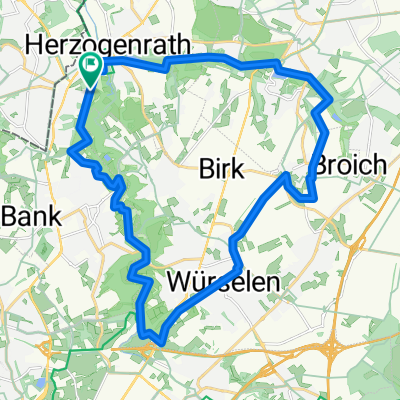
Vennbahnweg
A cycling route starting in Herzogenrath, North Rhine-Westphalia, Germany.
Overview
About this route
- -:--
- Duration
- 16.1 km
- Distance
- 163 m
- Ascent
- 100 m
- Descent
- ---
- Avg. speed
- 217 m
- Max. altitude

Route quality
Waytypes & surfaces along the route
Waytypes
Quiet road
8.4 km
(52 %)
Road
2.6 km
(16 %)
Surfaces
Paved
13.1 km
(81 %)
Asphalt
13.1 km
(81 %)
Undefined
3.1 km
(19 %)
Continue with Bikemap
Use, edit, or download this cycling route
You would like to ride Vennbahnweg or customize it for your own trip? Here is what you can do with this Bikemap route:
Free features
- Save this route as favorite or in collections
- Copy & plan your own version of this route
- Sync your route with Garmin or Wahoo
Premium features
Free trial for 3 days, or one-time payment. More about Bikemap Premium.
- Navigate this route on iOS & Android
- Export a GPX / KML file of this route
- Create your custom printout (try it for free)
- Download this route for offline navigation
Discover more Premium features.
Get Bikemap PremiumFrom our community
Other popular routes starting in Herzogenrath
 Limburgs Mooiste 2010 (rode lus 150 km)
- Distance
- 152.2 km
- Ascent
- 1,078 m
- Descent
- 1,085 m
- Location
- Herzogenrath, North Rhine-Westphalia, Germany
 AZAN Tour 2 An Wurm Und Broichbach
- Distance
- 29.4 km
- Ascent
- 146 m
- Descent
- 146 m
- Location
- Herzogenrath, North Rhine-Westphalia, Germany
 Von Herzogenrath bis Geldern
- Distance
- 88.8 km
- Ascent
- 186 m
- Descent
- 297 m
- Location
- Herzogenrath, North Rhine-Westphalia, Germany
 West-Bike-Tagestour
- Distance
- 74.9 km
- Ascent
- 448 m
- Descent
- 445 m
- Location
- Herzogenrath, North Rhine-Westphalia, Germany
 Tolle Landschaftsroute CLONED FROM ROUTE 220895
- Distance
- 25.5 km
- Ascent
- 162 m
- Descent
- 162 m
- Location
- Herzogenrath, North Rhine-Westphalia, Germany
 WINFOR
- Distance
- 23.3 km
- Ascent
- 110 m
- Descent
- 120 m
- Location
- Herzogenrath, North Rhine-Westphalia, Germany
 Testrunde Wurmtal
- Distance
- 22.8 km
- Ascent
- 689 m
- Descent
- 684 m
- Location
- Herzogenrath, North Rhine-Westphalia, Germany
 Tolle Landschaftsroute
- Distance
- 25.5 km
- Ascent
- 205 m
- Descent
- 222 m
- Location
- Herzogenrath, North Rhine-Westphalia, Germany
Open it in the app