

Trg Republike Hrvatske, Vukovar a Matice hrvatske 2, Sotin
A cycling route starting in Vukovar, Vukovar-Srijem County, Croatia.
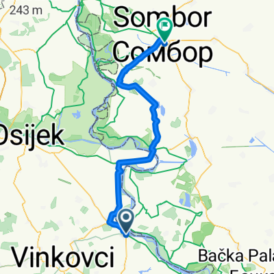
Overview
About this route
- 38 min
- Duration
- 10.6 km
- Distance
- 61 m
- Ascent
- 31 m
- Descent
- 16.8 km/h
- Avg. speed
- 117 m
- Max. altitude
Route quality
Waytypes & surfaces along the route
Waytypes
Busy road
5.4 km
(51 %)
Cycleway
3.2 km
(30 %)
Surfaces
Paved
7.4 km
(70 %)
Asphalt
5.7 km
(54 %)
Paving stones
1.3 km
(12 %)
Continue with Bikemap
Use, edit, or download this cycling route
You would like to ride Trg Republike Hrvatske, Vukovar a Matice hrvatske 2, Sotin or customize it for your own trip? Here is what you can do with this Bikemap route:
Free features
- Save this route as favorite or in collections
- Copy & plan your own version of this route
- Sync your route with Garmin or Wahoo
Premium features
Free trial for 3 days, or one-time payment. More about Bikemap Premium.
- Navigate this route on iOS & Android
- Export a GPX / KML file of this route
- Create your custom printout (try it for free)
- Download this route for offline navigation
Discover more Premium features.
Get Bikemap PremiumFrom our community
Other popular routes starting in Vukovar
 2018_Tag3_Vukovar_Bajina Basta
- Distance
- 244.4 km
- Ascent
- 909 m
- Descent
- 761 m
- Location
- Vukovar, Vukovar-Srijem County, Croatia
 x vukovar drenovci
- Distance
- 65.7 km
- Ascent
- 51 m
- Descent
- 74 m
- Location
- Vukovar, Vukovar-Srijem County, Croatia
 Bezdan
- Distance
- 73.1 km
- Ascent
- 64 m
- Descent
- 77 m
- Location
- Vukovar, Vukovar-Srijem County, Croatia
 Slawonien, Tag 4: Vukovar - Vucedol - Ilok
- Distance
- 38.3 km
- Ascent
- 177 m
- Descent
- 177 m
- Location
- Vukovar, Vukovar-Srijem County, Croatia
 danube cycling tour 2011 Stage 6 Vukovar (croatiea)to Novi sad(Serbie)
- Distance
- 81 km
- Ascent
- 132 m
- Descent
- 138 m
- Location
- Vukovar, Vukovar-Srijem County, Croatia
 09 Novi Sad
- Distance
- 76.4 km
- Ascent
- 125 m
- Descent
- 150 m
- Location
- Vukovar, Vukovar-Srijem County, Croatia
 Route from Dalmatinska ulica 5, Vukovar
- Distance
- 912.6 km
- Ascent
- 245 m
- Descent
- 334 m
- Location
- Vukovar, Vukovar-Srijem County, Croatia
 Vukovar to Backa Palanka
- Distance
- 42.3 km
- Ascent
- 246 m
- Descent
- 264 m
- Location
- Vukovar, Vukovar-Srijem County, Croatia
Open it in the app