

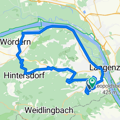
Um Wien umadum
A cycling route starting in Klosterneuburg, Lower Austria, Austria.
Overview
About this route
- -:--
- Duration
- 134.3 km
- Distance
- 1,181 m
- Ascent
- 1,180 m
- Descent
- ---
- Avg. speed
- 523 m
- Max. altitude

Route quality
Waytypes & surfaces along the route
Waytypes
Cycleway
29.6 km
(22 %)
Road
22.8 km
(17 %)
Surfaces
Paved
115.5 km
(86 %)
Asphalt
114.2 km
(85 %)
Concrete
1.3 km
(1 %)
Undefined
18.8 km
(14 %)
Continue with Bikemap
Use, edit, or download this cycling route
You would like to ride Um Wien umadum or customize it for your own trip? Here is what you can do with this Bikemap route:
Free features
- Save this route as favorite or in collections
- Copy & plan your own version of this route
- Split it into stages to create a multi-day tour
- Sync your route with Garmin or Wahoo
Premium features
Free trial for 3 days, or one-time payment. More about Bikemap Premium.
- Navigate this route on iOS & Android
- Export a GPX / KML file of this route
- Create your custom printout (try it for free)
- Download this route for offline navigation
Discover more Premium features.
Get Bikemap PremiumFrom our community
Other popular routes starting in Klosterneuburg
 Strandbad Birkenallee, Klosterneuburg to Obermüllnerstraße, Vienna
- Distance
- 12.9 km
- Ascent
- 38 m
- Descent
- 38 m
- Location
- Klosterneuburg, Lower Austria, Austria
 2005 - Passau - Györ - 6. Tag - Kierling - Hainburg
- Distance
- 64.8 km
- Ascent
- 79 m
- Descent
- 128 m
- Location
- Klosterneuburg, Lower Austria, Austria
 B 6 7 18
- Distance
- 21.6 km
- Ascent
- 364 m
- Descent
- 364 m
- Location
- Klosterneuburg, Lower Austria, Austria
 Höhenstraßen - Marathon (Wien)
- Distance
- 95.2 km
- Ascent
- 2,035 m
- Descent
- 1,947 m
- Location
- Klosterneuburg, Lower Austria, Austria
 Von Klosterneuburg bis Wien
- Distance
- 13 km
- Ascent
- 108 m
- Descent
- 203 m
- Location
- Klosterneuburg, Lower Austria, Austria
 gericht
- Distance
- 8.8 km
- Ascent
- 60 m
- Descent
- 170 m
- Location
- Klosterneuburg, Lower Austria, Austria
 Route in Klosterneuburg
- Distance
- 42.6 km
- Ascent
- 868 m
- Descent
- 870 m
- Location
- Klosterneuburg, Lower Austria, Austria
 KLBG-Dopplerhütte-Kreuzenstein
- Distance
- 78.1 km
- Ascent
- 694 m
- Descent
- 706 m
- Location
- Klosterneuburg, Lower Austria, Austria
Open it in the app