
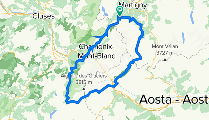
Hiking 120 Miles Alone on the Tour Du Mont Blanc Loop
A cycling route starting in Martigny-Combe, Valais, Switzerland.
Overview
About this route
The Tour du Mont Blanc is a 120 mile loop that circles the Mont Blanc Mastiff and passes through Swiss, French and Italian Alps. Each country’s section has its own personality. The trail is well-maintained and dotted with colorful “TMB” markers. You’ll find plenty of other people on this trail, all hiking for different reasons. It’s usually impossible to tell how long someone has been hiking because the trail is a loop with technically no starting or ending point. You’ll find thru-hikers with large packs doing the entire loop, day hikers, gondola tourists, trail runners, mountain bikers, families with dogs and locals taking their morning stroll. You pass tiny villages hidden in the mountains and large bustling cities filled with tourists. The trail is dotted with Refugios and campsites where you can eat, drink and sleep. The trail is safe, filled with people willing to help you out if need be and highly developed so anyone in good health and going at their own speed can complete the full loop. I recommend the Tour du Mont Blanc Loop for anyone attempting their first 100+ mile hike because of its beauty, moderate difficulty and low danger risk. While this is a very popular and hiked trail in Europe, you can still find quiet moments of isolation between towns and on the mountain passes high away from any roads or gondolas.
- -:--
- Duration
- 165.3 km
- Distance
- 12,832 m
- Ascent
- 12,837 m
- Descent
- ---
- Avg. speed
- 2,663 m
- Max. altitude

Continue with Bikemap
Use, edit, or download this cycling route
You would like to ride Hiking 120 Miles Alone on the Tour Du Mont Blanc Loop or customize it for your own trip? Here is what you can do with this Bikemap route:
Free features
- Save this route as favorite or in collections
- Copy & plan your own version of this route
- Split it into stages to create a multi-day tour
- Sync your route with Garmin or Wahoo
Premium features
Free trial for 3 days, or one-time payment. More about Bikemap Premium.
- Navigate this route on iOS & Android
- Export a GPX / KML file of this route
- Create your custom printout (try it for free)
- Download this route for offline navigation
Discover more Premium features.
Get Bikemap PremiumFrom our community
Other popular routes starting in Martigny-Combe
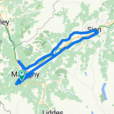
 La Chatelard-Lac de Emosson
- Distance
- 18.3 km
- Ascent
- 1,556 m
- Descent
- 838 m
- Location
- Martigny-Combe, Valais, Switzerland
 Hiking 120 Miles Alone on the Tour Du Mont Blanc Loop
- Distance
- 165.3 km
- Ascent
- 12,832 m
- Descent
- 12,837 m
- Location
- Martigny-Combe, Valais, Switzerland
 Trevor Base Route
- Distance
- 93.3 km
- Ascent
- 715 m
- Descent
- 715 m
- Location
- Martigny-Combe, Valais, Switzerland
 Route de la Forclaz, Martigny-Croix nach Chemin du Glacier de Taconnaz, Chamonix-Mont-Blanc
- Distance
- 35.6 km
- Ascent
- 658 m
- Descent
- 964 m
- Location
- Martigny-Combe, Valais, Switzerland
 Startup Route des Grandes Alpes
- Distance
- 40 km
- Ascent
- 1,360 m
- Descent
- 834 m
- Location
- Martigny-Combe, Valais, Switzerland
 2017 ALPS Etapa 7 - Le Grand St Bernanrd
- Distance
- 108.8 km
- Ascent
- 2,888 m
- Descent
- 2,896 m
- Location
- Martigny-Combe, Valais, Switzerland
 Trevor - Champex lac loop
- Distance
- 42.5 km
- Ascent
- 1,099 m
- Descent
- 1,099 m
- Location
- Martigny-Combe, Valais, Switzerland
 Champex and Val Ferret
- Distance
- 62.9 km
- Ascent
- 1,722 m
- Descent
- 1,722 m
- Location
- Martigny-Combe, Valais, Switzerland
Open it in the app