
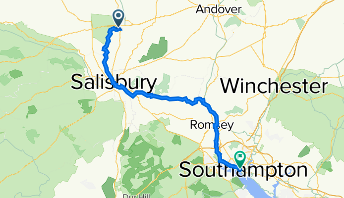
40 High St, Salisbury to 3 West Quay Road, Southampton
A cycling route starting in Amesbury, England, United Kingdom.
Overview
About this route
- 3 h 33 min
- Duration
- 59.5 km
- Distance
- 267 m
- Ascent
- 333 m
- Descent
- 16.7 km/h
- Avg. speed
- 100 m
- Max. altitude
Route quality
Waytypes & surfaces along the route
Waytypes
Road
31.8 km
(53 %)
Quiet road
13.3 km
(22 %)
Surfaces
Paved
37.5 km
(63 %)
Asphalt
37.4 km
(63 %)
Paving stones
0.1 km
(<1 %)
Undefined
22 km
(37 %)
Continue with Bikemap
Use, edit, or download this cycling route
You would like to ride 40 High St, Salisbury to 3 West Quay Road, Southampton or customize it for your own trip? Here is what you can do with this Bikemap route:
Free features
- Save this route as favorite or in collections
- Copy & plan your own version of this route
- Sync your route with Garmin or Wahoo
Premium features
Free trial for 3 days, or one-time payment. More about Bikemap Premium.
- Navigate this route on iOS & Android
- Export a GPX / KML file of this route
- Create your custom printout (try it for free)
- Download this route for offline navigation
Discover more Premium features.
Get Bikemap PremiumFrom our community
Other popular routes starting in Amesbury
 Amesbury-Stonehenge-Frome
- Distance
- 61.6 km
- Ascent
- 370 m
- Descent
- 397 m
- Location
- Amesbury, England, United Kingdom
 Bukford Durry Larkhill
- Distance
- 14.9 km
- Ascent
- 206 m
- Descent
- 230 m
- Location
- Amesbury, England, United Kingdom
 Upper Amesbury loop
- Distance
- 6.5 km
- Ascent
- 48 m
- Descent
- 48 m
- Location
- Amesbury, England, United Kingdom
 Newbury Drive 32, Amesbury to Newbury Drive 32, Amesbury
- Distance
- 9.1 km
- Ascent
- 123 m
- Descent
- 122 m
- Location
- Amesbury, England, United Kingdom
 Stonehenge-Weymouth
- Distance
- 124 km
- Ascent
- 688 m
- Descent
- 776 m
- Location
- Amesbury, England, United Kingdom
 Recovered Route
- Distance
- 172.6 km
- Ascent
- 75 m
- Descent
- 94 m
- Location
- Amesbury, England, United Kingdom
 11.etapa Stonehange - Salisbury - Hill Crest
- Distance
- 50.3 km
- Ascent
- 348 m
- Descent
- 389 m
- Location
- Amesbury, England, United Kingdom
 Amesbury loop through Woodfords
- Distance
- 16.4 km
- Ascent
- 147 m
- Descent
- 145 m
- Location
- Amesbury, England, United Kingdom
Open it in the app